
File:Beaumaris plan, Cadw.jpg
Size of this preview: 464 × 600 pixels. Other resolutions: 186 × 240 pixels | 633 × 818 pixels.
Original file (633 × 818 pixels, file size: 117 KB, MIME type: image/jpeg)
| This is a file from the Wikimedia Commons. Information from its description page there is shown below. Commons is a freely licensed media file repository. You can help. |
Summary
| Description |
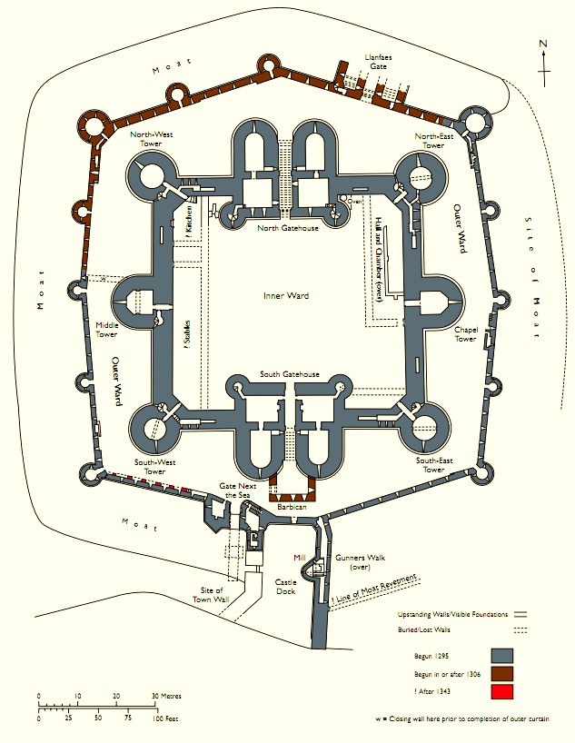
English: Cadw plan of Beaumaris castle |
||
| Date | Unknown date | ||
| Source | http://cadw.wales.gov.uk/docs/cadw/publications/WHS_additional_maps_plans_EN.pdf | ||
| Author | Cadw | ||
| Permission (Reusing this file) |
Copyright status at http://cadw.wales.gov.uk/copyright/?lang=en | ||
| Other versions |
|


Licensing
_(St_Edwards_Crown).svg)
|
This file is licensed under the Open Government Licence version 1.0 (OGL v1.0).
|
|---|---|
|
You are free to:
See the Open Government Licence page on Meta-Wiki for more information.
|
File history
Click on a date/time to view the file as it appeared at that time.
| Date/Time | Thumbnail | Dimensions | User | Comment | |
|---|---|---|---|---|---|
| current | 19:26, 17 September 2012 | | 633 × 818 (117 KB) | Hchc2009 | User created page with UploadWizard |
File usage
The following 2 pages use this file:
Global file usage
The following other wikis use this file:
- Usage on bg.wikipedia.org
- Usage on ca.wikipedia.org
- Usage on cs.wikipedia.org
- Usage on da.wikipedia.org
- Usage on de.wikipedia.org
- Usage on eu.wikipedia.org
- Usage on fa.wikipedia.org
- Usage on fi.wikipedia.org
- Usage on fr.wikipedia.org
- Usage on he.wikipedia.org
- Usage on hy.wikipedia.org
- Usage on ja.wikipedia.org
- Usage on ln.wikipedia.org
- Usage on nl.wikipedia.org
- Usage on ru.wikipedia.org
- Usage on sl.wikipedia.org
- Usage on sw.wikipedia.org
- Usage on uk.wikipedia.org
- Usage on vi.wikipedia.org
- Usage on www.wikidata.org