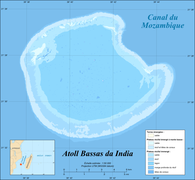
File:Bassas da India atoll map-fr.png
Appearance

Size of this preview: 650 × 600 pixels. Other resolutions: 260 × 240 pixels | 520 × 480 pixels | 832 × 768 pixels | 1,110 × 1,024 pixels | 1,555 × 1,435 pixels.
Original file (1,555 × 1,435 pixels, file size: 371 KB, MIME type: image/png)
File history
Click on a date/time to view the file as it appeared at that time.
| Date/Time | Thumbnail | Dimensions | User | Comment | |
|---|---|---|---|---|---|
| current | 13:51, 19 July 2010 |  | 1,555 × 1,435 (371 KB) | Sting | Color profile |
| 15:30, 17 November 2009 |  | 1,555 × 1,435 (373 KB) | Sting | Embedded sRGB profile | |
| 17:59, 6 June 2008 |  | 1,555 × 1,435 (329 KB) | Sting | Inkscape export bug correction | |
| 17:40, 6 June 2008 |  | 1,555 × 1,435 (331 KB) | Sting | == Summary == {{Location|21|28|39|S|39|41|07|E|scale:100000}} <br/>{{Information |Description={{en|Map in French of the French atoll of Bassas da India, [[:en:Scattered islands in the Indian Ocean|Scattered islands in the Indian Oc |
File usage
The following page uses this file:
Global file usage
The following other wikis use this file:
- Usage on ar.wikipedia.org
- Usage on ast.wikipedia.org
- Usage on ca.wikipedia.org
- Usage on ceb.wikipedia.org
- Usage on eo.wikipedia.org
- Usage on es.wikipedia.org
- Usage on eu.wikipedia.org
- Usage on fr.wikipedia.org
- Usage on gl.wikipedia.org
- Usage on ko.wikipedia.org
- Usage on mg.wikipedia.org
- Usage on mk.wikipedia.org
- Usage on pl.wikipedia.org
- Usage on pt.wikipedia.org
- Usage on ro.wikipedia.org
- Usage on sq.wikipedia.org
- Usage on sv.wikipedia.org
- Usage on tr.wikipedia.org
- Usage on uk.wikipedia.org
- Usage on ur.wikipedia.org
- Usage on vi.wikipedia.org
- Usage on www.wikidata.org
- Usage on zh.wikipedia.org


