Jump to content

File:Appalachian Pennsylvania salient satfoto.jpg

Page contents not supported in other languages.
This is a file from the Wikimedia Commons
From Wikipedia, the free encyclopedia

Original file (720 × 720 pixels, file size: 275 KB, MIME type: image/jpeg)

Description
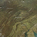
English: For decades, geologists have debated the origins of an unmistakable curve in the Appalachian Mountains. Known to experts as the “Pennsylvania salient,” the bend begins in southern New York and northeastern Pennsylvania and extends across Pennsylvania to the border of Maryland. In this area, the ridges of the Appalachians turn from a roughly north-south orientation to an east-west orientation and then north-south again.

A recent study, authored by geologists from the University of Rochester and College of New Jersey, focuses on a block of dense, mafic volcanic rock beneath the bend. The scientists argued that this underground mass forced the mountain chain to shift as it formed hundreds of millions of years ago. As the North American and African plates collided, the North American plate began to fold and thrust upward. However, the mass of volcanic rock became a barrier and forced the mountains to push up around it.

Geologists have known about this mass for some time, but after analyzing new seismic and gravitational data, they concluded that the expanse of volcanic rocks was about 450 kilometers (286 miles) by 100 kilometers (124 miles). “What we didn’t understand was the size of the structure or its implications for mountain-building processes,” said Cynthia Ebinger, one of the study authors.

The Moderate Resolution Imaging Spectroradiometer (MODIS) on NASA’s Aqua satellite captured this view of the bend on November 17, 2012. Other physiographic regions are also visible. A portion of the Appalachian Plateau lies to the north of the mountains. The Appalachian Piedmont, a low-elevation plateau in the foothills, lies to the east and transitions into the Atlantic Coastal Plain.

References (links at source)

  • Benoit, M. et al (2014, April 28) Orogenic bending around a rigid Proterozoic magmatic rift beneath the Central Appalachian Mountains. Earth and Planetary Science Letters, 402 (15), 197-208.
  • Commonwealth of Pennsylvania Physiographic Provinces of Pennsylvania. Accessed September 17, 2014.
  • Geomorphology from Space (1986) Folded Appalachians Accessed September 17, 2014.
  • Maryland Geologic Survey Physiographic Map of Maryland. Accessed September 17, 2014.
University of Rochester (2014, July 18) Bend in Appalachian mountain chain finally explained. Accessed September 17, 2014.
Date
Source http://earthobservatory.nasa.gov/IOTD/view.php?id=84393&src=eoa-iotd
Author NASA Moderate Resolution Imaging Spectroradiometer (MODIS) on NASA’s Aqua satellite
Permission
(Reusing this file)
Public domain This file is in the public domain in the United States because it was solely created by NASA. NASA copyright policy states that "NASA material is not protected by copyright unless noted". (See Template:PD-USGov, NASA copyright policy page or JPL Image Use Policy.)
Warnings:

Captions

Add a one-line explanation of what this file represents

Items portrayed in this file

depicts

17 November 2012

image/jpeg

0a52681d4775a93221267a1414eadd1b80f30f14

281,723 byte

720 pixel

720 pixel

File history

Click on a date/time to view the file as it appeared at that time.

Date/TimeThumbnailDimensionsUserComment
current00:31, 24 September 2014Thumbnail for version as of 00:31, 24 September 2014720 × 720 (275 KB)Tillman{{Information |Description ={{en|1= For decades, geologists have debated the origins of an unmistakable curve in the Appalachian Mountains. Known to experts as the “Pennsylvania salient,” the bend begins in southern New York and northeastern Pe...

The following 2 pages use this file:

Global file usage

The following other wikis use this file:

Metadata