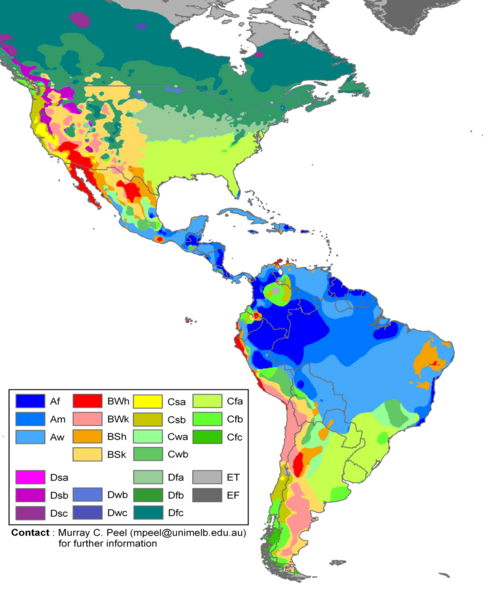
File:Americas Köppen Map.png
Appearance

Size of this preview: 483 × 599 pixels. Other resolutions: 193 × 240 pixels | 387 × 480 pixels | 619 × 768 pixels | 1,096 × 1,360 pixels.
Original file (1,096 × 1,360 pixels, file size: 520 KB, MIME type: image/png)
File history
Click on a date/time to view the file as it appeared at that time.
| Date/Time | Thumbnail | Dimensions | User | Comment | |
|---|---|---|---|---|---|
| current | 19:20, 20 February 2018 |  | 1,096 × 1,360 (520 KB) | Maphobbyist | The Costa Rican Central Valley has a dry winter oceanic climate (Köppen classification: Cwb). |
| 00:19, 8 February 2018 |  | 1,096 × 1,360 (433 KB) | WolfmanSF | Reverted to version as of 10:48, 27 December 2008 (UTC) - the northernmost areas aren't of much interest for the purposes of the Great American Interchange article which uses this image | |
| 21:30, 7 February 2018 |  | 1,860 × 1,593 (526 KB) | Maphobbyist | Included Alaska, Northern Canada and Greenland which were omitted. | |
| 10:48, 27 December 2008 |  | 1,096 × 1,360 (433 KB) | WolfmanSF | {{Information |Description= |Source= |Date= |Author= |Permission= |other_versions= }} | |
| 21:46, 21 December 2008 |  | 1,096 × 1,360 (439 KB) | WolfmanSF | rotate legend to make lettering horizontal; remove boxes for unused climate zones | |
| 05:21, 5 May 2008 |  | 1,096 × 1,360 (428 KB) | WolfmanSF | {{Information |Description=Updated world map of the Köppen-Geiger climate classification. |Source=[http://www.hydrol-earth-syst-sci.net/11/1633/2007/hess-11-1633-2007.html Hydrology and Earth System Sciences: "Updated world map of the Köppen-Geiger clim |
File usage
The following 3 pages use this file:
Global file usage
The following other wikis use this file:
- Usage on az.wikipedia.org
- Usage on bg.wikipedia.org
- Usage on es.wikipedia.org
- Usage on fr.wikipedia.org
- Usage on he.wikipedia.org
- Usage on nl.wikipedia.org
- Usage on uk.wikipedia.org

