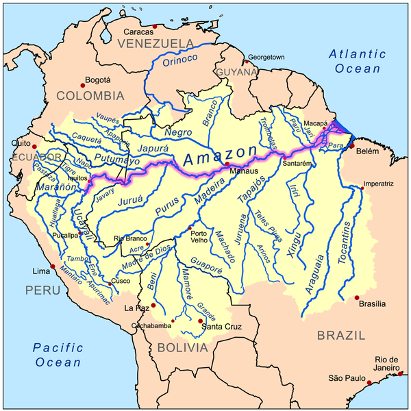
File:Amazonrivermap.png
Appearance

Size of this preview: 600 × 600 pixels. Other resolutions: 240 × 240 pixels | 480 × 480 pixels | 1,000 × 1,000 pixels.
Original file (1,000 × 1,000 pixels, file size: 551 KB, MIME type: image/png)
File history
Click on a date/time to view the file as it appeared at that time.
| Date/Time | Thumbnail | Dimensions | User | Comment | |
|---|---|---|---|---|---|
| current | 19:02, 19 December 2022 |  | 1,000 × 1,000 (551 KB) | Italyoz484 | |
| 17:04, 1 September 2022 |  | 1,000 × 1,000 (583 KB) | Wolf170278 | Tocantins doesn't belong to the amazon river basin | |
| 17:15, 8 September 2008 |  | 1,000 × 1,000 (551 KB) | Kmusser | {{Information |Description=This is a map of the Amazon River drainage basin with the Amazon River highlighted. |Source=Own work using http://www.maproom.psu.edu/dcw/ Digital Chart of the World and [[http://edc.usgs.gov/products/el |
File usage
The following 4 pages use this file:
Global file usage
The following other wikis use this file:
- Usage on da.wikipedia.org
- Usage on de.wikipedia.org
- Usage on de.wikinews.org
- Usage on he.wikipedia.org
- Usage on ko.wikipedia.org
- Usage on lez.wikipedia.org
- Usage on nn.wikipedia.org
- Usage on no.wikipedia.org


