
File:Afon Irfon, below the Devil's Staircase, Powys - geograph.org.uk - 1071151.jpg
No higher resolution available.
Afon_Irfon,_below_the_Devil's_Staircase,_Powys_-_geograph.org.uk_-_1071151.jpg (640 × 480 pixels, file size: 157 KB, MIME type: image/jpeg)
| This is a file from the Wikimedia Commons. Information from its description page there is shown below. Commons is a freely licensed media file repository. You can help. |
Summary
| Description |
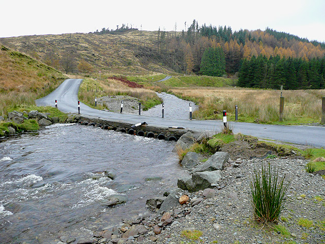
English: Afon Irfon, below the Devil's Staircase, Powys The former drovers' road to Tregaron crosses the Afon Irfon near Llanerch-yrfa three times in four hundred metres. This used to be by means of fords, as marked on most maps. (Does anyone have access to photographs showing how it used to be?). Now, each one has been built up by means of piped culverts under concrete/asphalt - a structure known as an Irish bridge. In times of flood, these are covered, and can be used as fords. Heavy rain fell about 36 hours before this image was taken, and a lot more was forecast as I made my "escape". |
| Date | |
| Source | From geograph.org.uk |
| Author | Roger Kidd |
| Attribution (required by the license) | Roger Kidd / Afon Irfon, below the Devil's Staircase, Powys / |
| Camera location | | View this and other nearby images on: OpenStreetMap |
|---|
_heading:315.00&language=en)
| Object location | | View this and other nearby images on: OpenStreetMap |
|---|
_heading:315.00&language=en)
Licensing

|
This image was taken from the Geograph project collection. See this photograph's page on the Geograph website for the photographer's contact details. The copyright on this image is owned by Roger Kidd and is licensed for reuse under the Creative Commons Attribution-ShareAlike 2.0 license.
|
This file is licensed under the Creative Commons Attribution-Share Alike 2.0 Generic license.
Attribution: Roger Kidd
- You are free:
- to share – to copy, distribute and transmit the work
- to remix – to adapt the work
- Under the following conditions:
- attribution – You must give appropriate credit, provide a link to the license, and indicate if changes were made. You may do so in any reasonable manner, but not in any way that suggests the licensor endorses you or your use.
- share alike – If you remix, transform, or build upon the material, you must distribute your contributions under the same or compatible license as the original.
File history
Click on a date/time to view the file as it appeared at that time.
| Date/Time | Thumbnail | Dimensions | User | Comment | |
|---|---|---|---|---|---|
| current | 06:37, 24 February 2011 | | 640 × 480 (157 KB) | GeographBot | == {{int:filedesc}} == {{Information |description={{en|1=Afon Irfon, below the Devil's Staircase, Powys The former drovers' road to Tregaron crosses the Afon Irfon near Llanerch-yrfa three times in four hundred metres. This used to be by means of fords, a |
File usage
The following pages on the English Wikipedia use this file (pages on other projects are not listed):
Global file usage
The following other wikis use this file:
- Usage on ceb.wikipedia.org
- Usage on cy.wikipedia.org
- Usage on de.wikipedia.org
- Usage on fr.wikipedia.org
- Usage on sv.wikipedia.org
- Usage on www.wikidata.org