Jump to content

File:1896 U.S. Geological Survey Geological Map of Yellowstone National Park (4 sheets) - Geographicus - YellowstoneGeo-usgs-1896.jpg

Page contents not supported in other languages.
This is a file from the Wikimedia Commons
From Wikipedia, the free encyclopedia

Original file(5,000 × 6,023 pixels, file size: 9.54 MB, MIME type: image/jpeg)

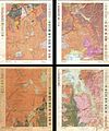
Yellowstone National Park, Gallatin Sheet. - Yellowstone National Park - Wyoming, Lake Sheet - Yellowstone National Park - Wyoming, Shoshone Sheet. - Yellowstone National Park, Canyon Sheet.
Artist
Title
Yellowstone National Park, Gallatin Sheet. - Yellowstone National Park - Wyoming, Lake Sheet - Yellowstone National Park - Wyoming, Shoshone Sheet. - Yellowstone National Park, Canyon Sheet.
Description
English: This is the rare U.S. Geological Survey of Yellowstone National Park in four sheets. Depicts the entire park in considerable detail noting topography, hot springs, rivers and creeks, marshes, geysers, lakes and ponds. Also specifically notes the Continental Divide. Shaded to illustrate different types of rock and geological zones. Divided into four sheets: the Canyon Sheet, the Lake Sheet, the Gallatin Sheet and the Shoshone sheet. Published by the U.S. Geological survey based on surveys conducted between 1884 and 1885 under Henry Gannett, Chief Geographer and J. H. Renshawe, Geographer in charge of the expedition. The topography for this map is the work of Frank Tweedy, S. A. Aaplin Jr., J. H. Renshawe and W. H. Leffingwell. Triangulation was accomplished by H. S. Chase. This is the April 1896 edition. Each sheet measures 19.5 x 15 inches.
Date 1896 (dated)
Dimensions height: 19.5 in (49.5 cm); width: 15 in (38.1 cm)
dimensions QS:P2048,19.5U218593
dimensions QS:P2049,15U218593
Accession number
Geographicus link: YellowstoneGeo-usgs-1896
Source/Photographer

Walcott, Charles D., Geologic Atlas of the United States Yellowstone National Park Folio Wyoming. (1896 edition).

Permission
(Reusing this file)
This is a faithful photographic reproduction of a two-dimensional, public domain work of art. The work of art itself is in the public domain for the following reason:
Public domain

This work is in the public domain in its country of origin and other countries and areas where the copyright term is the author's life plus 70 years or fewer.


You must also include a United States public domain tag to indicate why this work is in the public domain in the United States.
The official position taken by the Wikimedia Foundation is that "faithful reproductions of two-dimensional public domain works of art are public domain".
This photographic reproduction is therefore also considered to be in the public domain in the United States. In other jurisdictions, re-use of this content may be restricted; see Reuse of PD-Art photographs for details.
{{PD-Art}} template without license parameter: please specify why the underlying work is public domain in both the source country and the United States
(Usage: {{PD-Art|1=|deathyear=''year of author's death''|country=''source country''}}, where parameter 1= can be PD-old-auto, PD-old-auto-expired, PD-old-auto-1996, PD-old-100 or similar. See Commons:Multi-license copyright tags for more information.)

Captions

Add a one-line explanation of what this file represents

Items portrayed in this file

depicts

image/jpeg

3a91bc25cb880abca119215eb631e86a7c8dac0c

9,999,578 byte

6,023 pixel

5,000 pixel

File history

Click on a date/time to view the file as it appeared at that time.

Date/TimeThumbnailDimensionsUserComment
current09:09, 18 March 2011Thumbnail for version as of 09:09, 18 March 20115,000 × 6,023 (9.54 MB)BotMultichill{{subst:User:Multichill/Geographicus |link=http://www.geographicus.com/P/AntiqueMap/YellowstoneGeo-usgs-1896 |product_name=1896 U.S. Geological Survey Geological Map of Yellowstone National Park (4 sheets) |map_title=Yellowstone National Park, Gallatin Sh
The following pages on the English Wikipedia use this file (pages on other projects are not listed):