Jump to content

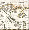
File:1771 Bonne Map of Tonkin and Cochinchina (Vietnam).jpg

Page contents not supported in other languages.
This is a file from the Wikimedia Commons
From Wikipedia, the free encyclopedia

Original file (1,154 × 1,189 pixels, file size: 436 KB, MIME type: image/jpeg)

Rigobert Bonne: Carte Hydro-Geo-Graphique des Indes Orientales en deca et au dela du Gange avec leur Archipel Dressee et assujettie aux Observations Astronomiques.   (Wikidata search (Cirrus search) Wikidata query (SPARQL)  Create new Wikidata item based on this file)
Artist
Rigobert Bonne  (1727–)  wikidata:Q721492
 
Description French cartographer
Date of birth/death 6 October 1727 Edit this at Wikidata 2 September 1794 / 29 November 1795 Edit this at Wikidata
Location of birth/death Raucourt Edit this at Wikidata former 9th arrondissement of Paris Edit this at Wikidata
Work location
Authority file
artist QS:P170,Q721492
Title
Carte Hydro-Geo-Graphique des Indes Orientales en deca et au dela du Gange avec leur Archipel Dressee et assujettie aux Observations Astronomiques.
Description
English: A beautiful example of Rigobert Bonne's 1771 uncommon map of southeastern China. Covers from the Kingdom of Siam (Thailand) to include Laos, Tonkin (northern Vietnam), Cochin Chi (southern Vietnam), the island of Hainan, Formosa (Taiwan) and the Island of Luzon (northern Philippines). Notes Macao and Canton and shows, but does not label, Hong Kong Island. Tayoan is noted on Formosa. Offers little inland detail with regard to China itself. Notes in the upper right hand corner comment on the Monsoons. Rhumb lines throughout. Arrows in the lower right show the direction of the prevailing winds. A fine map of the region. Drawn by R. Bonne in 1771 for issue as plate no. C 26 in Jean Lattre's 1776 issue of the Atlas Moderne .
Date 1771 (dated)
Dimensions height: 12 in (30.4 cm); width: 16.5 in (41.9 cm)
dimensions QS:P2048,12U218593
dimensions QS:P2049,16.5U218593
Accession number
Geographicus link: Formosa-bonne-1771
Source/Photographer

Lattre, Jean, Atlas Moderne ou Collection de Cartes sur Toutes les Parties du Globe Terrestre, c. 1775.

Permission
(Reusing this file)
This is a faithful photographic reproduction of a two-dimensional, public domain work of art. The work of art itself is in the public domain for the following reason:
Public domain

This work is in the public domain in its country of origin and other countries and areas where the copyright term is the author's life plus 100 years or fewer.


You must also include a United States public domain tag to indicate why this work is in the public domain in the United States.
This file has been identified as being free of known restrictions under copyright law, including all related and neighboring rights.
The official position taken by the Wikimedia Foundation is that "faithful reproductions of two-dimensional public domain works of art are public domain".
This photographic reproduction is therefore also considered to be in the public domain in the United States. In other jurisdictions, re-use of this content may be restricted; see Reuse of PD-Art photographs for details.
Other versions
image extraction process
This file has been extracted from another file
: 1771 Bonne Map of Tonkin (Vietnam) China, Formosa (Taiwan) and Luzon (Philippines) - Geographicus - Formosa-bonne-1771.jpg
original file

Captions

Add a one-line explanation of what this file represents

Items portrayed in this file

depicts

image/jpeg

67fa1430d9ced7ab25de39cd4b9931b7b58e2824

446,824 byte

1,189 pixel

1,154 pixel

File history

Click on a date/time to view the file as it appeared at that time.

Date/TimeThumbnailDimensionsUserComment
current09:16, 30 April 2021Thumbnail for version as of 09:16, 30 April 20211,154 × 1,189 (436 KB)Ltn12345File:1771 Bonne Map of Tonkin (Vietnam) China, Formosa (Taiwan) and Luzon (Philippines) - Geographicus - Formosa-bonne-1771.jpg cropped 71 % horizontally, 59 % vertically using CropTool with lossless mode.

The following 2 pages use this file:

Global file usage

The following other wikis use this file: