
File:1770 Janvier Map of Hungary, Romania, Transylvania, Moldova, Croatia and Bosnia - Geographicus - Hongrie-janvier-1770.jpg

Size of this preview: 800 × 561 pixels. Other resolutions: 320 × 224 pixels | 640 × 449 pixels | 1,024 × 718 pixels | 1,280 × 898 pixels | 2,560 × 1,795 pixels | 4,000 × 2,805 pixels.
Original file (4,000 × 2,805 pixels, file size: 3.45 MB, MIME type: image/jpeg)
| This is a file from the Wikimedia Commons. Information from its description page there is shown below. Commons is a freely licensed media file repository. You can help. |
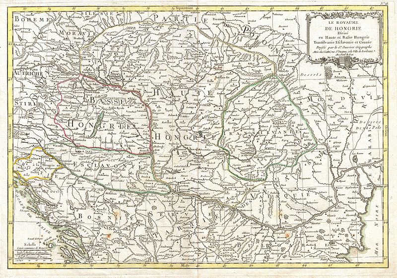
| Jean Janvier: The Royaume de Hongrie Divisee en Haute et Basse Hongrie, Transilvanie, Esclavonie et Croatie.
( |
|||||||||||||||||
|---|---|---|---|---|---|---|---|---|---|---|---|---|---|---|---|---|---|
| Artist |
|
||||||||||||||||
| Title |
The Royaume de Hongrie Divisee en Haute et Basse Hongrie, Transilvanie, Esclavonie et Croatie. |
||||||||||||||||
| Description |
English: A beautiful example of Le Sieur Janvier's 1771 map of southeastern Europe. Covers much of modern Hungary, Romania, Transylvania, Moldova, Bosnia, Serbia, Croatia, Bulgaria, and parts of Austria, Poland, and Greece. A decorative title cartouche bearing royal crest of Hungary appears in the upper right hand quadrant. A fine map of the region. Drawn by J. Janvier in 1771 for issue as plate no. 18 in Jean Lattre's 1776 issue of the Atlas Moderne . |
||||||||||||||||
| Date | 1770 (undated) | ||||||||||||||||
| Dimensions | height: 12.5 in (31.7 cm); width: 18 in (45.7 cm) | ||||||||||||||||
| Accession number |
Geographicus link: Hongrie-janvier-1770 |
||||||||||||||||
| Source/Photographer |
Lattre, Jean, Atlas Moderne ou Collection de Cartes sur Toutes les Parties du Globe Terrestre, c. 1775.
|
||||||||||||||||
| Permission (Reusing this file) |
|
||||||||||||||||
File history
Click on a date/time to view the file as it appeared at that time.
| Date/Time | Thumbnail | Dimensions | User | Comment | |
|---|---|---|---|---|---|
| current | 02:49, 23 March 2011 | | 4,000 × 2,805 (3.45 MB) | BotMultichillT | {{subst:User:Multichill/Geographicus |link=http://www.geographicus.com/P/AntiqueMap/Hongrie-janvier-1770 |product_name=1770 Janvier Map of Hungary, Romania, Transylvania, Moldova, Croatia and Bosnia |map_title=The Royaume de Hongrie Divisee en Haute et Ba |
File usage
The following 2 pages use this file:
Global file usage
The following other wikis use this file:
- Usage on hr.wikipedia.org
- Usage on hu.wikipedia.org
- Usage on sh.wikipedia.org
- Usage on sr.wikipedia.org