Jump to content

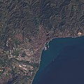
File:(Málaga) Strait of Gibraltar, Mediterranean Sea (cropped).jpg

Page contents not supported in other languages.
This is a file from the Wikimedia Commons
From Wikipedia, the free encyclopedia

Original file (1,356 × 1,352 pixels, file size: 662 KB, MIME type: image/jpeg)

Summary

Description
English: Observational Data courtesy of Landsat 8 satellite (Bands: 2, 3, 4, 8) & USGS. Data processed by Paul Quast.

Data Specifications: Coordinates: 36.0208, -5.1121. Acquired: 17-Jan-2017 (Entity ID: LC82010352017017LGN00, Path: 201, Row: 35).

Features of interest: Gibraltar [Middle]. Tangier, Morocco [Middle-Left]. Malaga, Spain [Top-Right].

Parque Natural Los Alcomocales [Middle].
Date
Source https://www.flickr.com/photos/148318224@N03/34540745262/
Author O.V.E.R.V.I.E.W.
Other versions
image extraction process
This file has been extracted from another file
: Strait of Gibraltar, Mediterranean Sea.jpg
original file
Camera location36° 02′ 32.77″ N, 5° 09′ 19.2″ W Kartographer map based on OpenStreetMap.View this and other nearby images on: OpenStreetMapinfo

Licensing

w:en:Creative Commons
attribution
This file is licensed under the Creative Commons Attribution 2.0 Generic license.
You are free:
  • to share – to copy, distribute and transmit the work
  • to remix – to adapt the work
Under the following conditions:
  • attribution – You must give appropriate credit, provide a link to the license, and indicate if changes were made. You may do so in any reasonable manner, but not in any way that suggests the licensor endorses you or your use.

Captions

Add a one-line explanation of what this file represents

Items portrayed in this file

depicts

36°2'32.770"N, 5°9'19.202"W

4 May 2017

image/jpeg

7ea657aae3c54b53d094a9e2efe8c058156360fc

678,107 byte

1,352 pixel

1,356 pixel

File history

Click on a date/time to view the file as it appeared at that time.

Date/TimeThumbnailDimensionsUserComment
current21:11, 4 August 2020Thumbnail for version as of 21:11, 4 August 20201,356 × 1,352 (662 KB)Up and GoFile:Strait of Gibraltar, Mediterranean Sea.jpg cropped 89 % horizontally, 90 % vertically using CropTool with lossless mode.

The following page uses this file:

Metadata