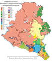
File:Этническая карта ЮФО и СКФО по городским и сельским поселениям.png
Appearance

Size of this preview: 522 × 600 pixels. Other resolutions: 209 × 240 pixels | 418 × 480 pixels | 668 × 768 pixels | 891 × 1,024 pixels | 1,783 × 2,048 pixels | 2,958 × 3,398 pixels.
Original file (2,958 × 3,398 pixels, file size: 942 KB, MIME type: image/png)
File history
Click on a date/time to view the file as it appeared at that time.
| Date/Time | Thumbnail | Dimensions | User | Comment | |
|---|---|---|---|---|---|
| current | 02:33, 29 May 2023 |  | 2,958 × 3,398 (942 KB) | DigitalSpace | Коррекция этнических границ на юге Дагестана |
| 03:56, 26 May 2022 |  | 2,958 × 3,398 (941 KB) | Игорь Темиров | Улучшенная версия (без логотипа) | |
| 09:03, 8 May 2022 |  | 2,958 × 3,398 (1,012 KB) | LandRussia | исправлена административная сетка и название карты, убраны не-этносы | |
| 17:32, 19 July 2021 |  | 1,479 × 1,699 (642 KB) | LandRussia | добавил аккинцев | |
| 15:01, 5 May 2021 |  | 1,479 × 1,699 (626 KB) | LandRussia | добавлены остальные этносы, разделены переписные этносы | |
| 20:55, 21 December 2020 |  | 1,479 × 1,699 (504 KB) | LandRussia | Uploaded own work with UploadWizard |
File usage
The following page uses this file:
Global file usage
The following other wikis use this file:
- Usage on ba.wikipedia.org
- Usage on bg.wikipedia.org
- Usage on ru.wikipedia.org
