Ekenäs Archipelago National Park
This article needs to be updated. (August 2014) |
| Ekenäs Archipelago National Park | |
|---|---|
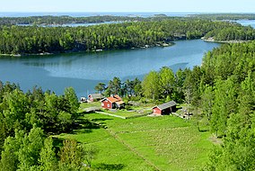
 Rödjan farmstead on Älgö island, the information centre of the national park | |
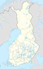
| Location | Uusimaa, Finland |
| Coordinates | 59°49′22″N 23°27′15″E / 59.82278°N 23.45417°E |
| Area | 52 km2 (20 sq mi) |
| Established | 1989 |
| Visitors | 44500 (in 2009[1]) |
| Governing body | Metsähallitus |
| Website | www |
Ekenäs Archipelago National Park (Swedish: Ekenäs skärgårds nationalpark, Finnish: Tammisaaren saariston kansallispuisto) is situated in the Ekenäs archipelago, in the Uusimaa region of Finland. It was established in 1989 and covers 52 square kilometres (20 sq mi). The park is maintained by Metsähallitus (Ministry of Forestry).
Most of the park's area is composed of rock islets near the open sea, and the water areas surrounding them. Landing on and using motorboats near the most important bird islands is forbidden from April 1 to July 17, to protect the nesting of aquatic birds.
The park can only be accessed by boat. Visitors without a boat can reach it by a water taxi.
Ekenäs Archipelago National Park received the European Diploma of Protected Areas on June 19, 1996. It was valid until June 2011.
See also
[edit]References
[edit]- ^ "Käyntimäärät kansallispuistoittain 2009" (in Finnish). Metsähallitus. Archived from the original on March 8, 2012. Retrieved September 29, 2010.
External links
[edit]


