Duki District
Appearance
(Redirected from Duki, Pakistan)
This article needs additional citations for verification. (January 2019) |
Duki District
ضلع دوکی دوکي ولسوالۍ دوکی دمگ | |
|---|---|
 Hairan Haiderzai Mound | |
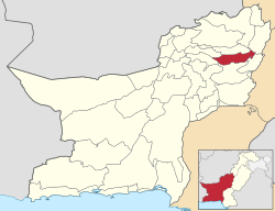
 Map of Balochistan with Duki District highlighted | |
| Country | |
| Province | |
| Division | Loralai |
| Established | 2016 |
| Headquarters | Duki |
| Government | |
| • Type | District Administration |
| • Deputy Commissioner | N/A |
| • District Police Officer | N/A |
| • District Health Officer | N/A |
| Area | |
• District of Balochistan | 4,233 km2 (1,634 sq mi) |
| Population (2023) | |
• District of Balochistan | 205,044 |
| • Density | 48/km2 (130/sq mi) |
| • Urban | 9,783 |
| • Rural | 195,261 |
| Time zone | UTC+5 (PKT) |
Duki (Urdu: ضلع دوکی) is a district in the Balochistan province of Pakistan.[1]
Administration
[edit]| Tehsil | Area
(km²)[2] |
Pop.
(2023) |
Density
(ppl/km²) (2023) |
Literacy rate
(2023)[3] |
Union Councils |
|---|---|---|---|---|---|
| Duki Tehsil | 938 | 137,294 | 146.37 | 50.48% | ... |
Demographics
[edit]| Year | Pop. | ±% p.a. |
|---|---|---|
| 1951 | N/A | — |
| 1961 | N/A | — |
| 1972 | N/A | — |
| 1981 | N/A | — |
| 1998 | 115,976 | — |
| 2017 | 152,977 | +1.47% |
| 2023 | 205,044 | +5.00% |
| Sources:[4] | ||
As of the 2023 census, Duki district has 43,059 households and a population of 205,044. The district has a sex ratio of 109.66 males to 100 females and a literacy rate of 44.18%: 53.91% for males and 33.43% for females.[5][6] 67,333 (32.84% of the surveyed population) are under 10 years of age.[7] 9,783 (4.77%) live in urban areas.[5]
Religion
[edit]| Religion | 1941[8][a] | 2017[9] | 2023[10] | |||
|---|---|---|---|---|---|---|
| Pop. | % | Pop. | % | Pop. | % | |
| Islam |
19,216 | 98.04% | 152,771 | 99.87% | 204,086 | 99.53% |
| Hinduism |
356 | 1.82% | 47 | 0.03% | 39 | 0.02% |
| Christianity |
26 | 0.13% | 116 | 0.08% | 799 | 0.39% |
| Others | 2 | 0.01% | 43 | 0.02% | 120 | 0.06% |
| Total Population | 19,600 | 100% | 152,977 | 100% | 205,044 | 100% |
Language
[edit]At the time of the 2023 census, 93.27% of the population spoke Pashto, 4.85% Balochi, and 0.69% Brahui as their first language.[11]
Notes
[edit]- ^ Duki tehsil of erstwhile Loralai Agency, which roughly corresponds to the present district. District and tehsil borders have shifted since 1941.
References
[edit]- ^ Tehsils & Unions in the District of Loralai - Government Archived March 26, 2012, at the Wayback Machine
- ^ "TABLE 1 : AREA, POPULATION BY SEX, SEX RATIO, POPULATION DENSITY, URBAN POPULATION, HOUSEHOLD SIZE AND ANNUAL GROWTH RATE, CENSUS-2023, BALOCHISTAN" (PDF).
- ^ "LITERACY RATE, ENROLMENT AND OUT OF SCHOOL POPULATION BY SEX AND RURAL/URBAN, CENSUS-2023, BALOCHISTAN" (PDF).
- ^ "Population by administrative units 1951-1998" (PDF). Pakistan Bureau of Statistics.
- ^ a b "7th Population and Housing Census - Detailed Results: Table 1" (PDF). Pakistan Bureau of Statistics.
- ^ "7th Population and Housing Census - Detailed Results: Table 12" (PDF). Pakistan Bureau of Statistics.
- ^ "7th Population and Housing Census: Population by Mother Tongue, Sex and Rural/Urban" (PDF). Pakistan Bureau of Statistics.
- ^ "Census of India, 1941. Vol. 14, Baluchistan". Retrieved 14 October 2021.
- ^ "Pakistan Census 2017 District-Wise Tables: Peshawar". Pakistan Bureau of Statistics.
- ^ "7th Population and Housing Census - Detailed Results: Table 9" (PDF). Pakistan Bureau of Statistics.
- ^ "7th Population and Housing Census: Population by Mother Tongue, Sex and Rural/Urban" (PDF). Pakistan Bureau of Statistics.

