
Culiacán: Difference between revisions
L Kensington (talk | contribs) m Reverted 1 edit by 200.77.79.223 identified as vandalism to last revision by 129.108.96.37. (TW) |
|||
| Line 69: | Line 69: | ||
===Foundation=== |
===Foundation=== |
||
The city existing today was founded in 1531 by the Spanish captain [[Nuño Beltrán de Guzmán]] and named ''San Miguel de Culiacán''. In the same decade, it was the terminus of the long journey of [[Cabeza de Vaca]] and company among natives. Explorer [[Francisco Vásquez de Coronado]] set out from Culiacán to explore what is now the southwestern United States. Settlers from [[Europe]] came to Culiacán, and in the following centuries, Culiacán continued to be a quiet town. It was only after the federal government built dams in the adjacent areas in the 1950s that [[agriculture]] exploded and the city began to grow exponentially. Some of Mexico's largest agricultural conglomerates operate in the vast and fertile coastal plains. The agro-industrial economy continues to be the single largest contributor to the region's legal economy. While the vast majority of technical and skilled labor is educated locally, the once-seasonal field labor pool now experiences a yearly shortage of workers. International patterns of migration now draw laborers from deep within Mexico's south to the northern border states and into the United States. |
The city existing today was founded in 1531 by the Spanish captain [[Nuño Beltrán de Guzmán]] and named ''San Miguel de Culiacán''. In the same decade, it was the terminus of the long journey of [[Cabeza de Vaca]] and company among natives. Explorer [[Francisco Vásquez de Coronado]] set out from Culiacán to explore what is now the southwestern United States. Settlers from [[Europe]] came to Culiacán, and in the following centuries, Culiacán continued to be a quiet town. It was only after the federal government built dams in the adjacent areas in the 1950s that [[agriculture]] exploded and the city began to grow exponentially. Some of Mexico's largest agricultural conglomerates operate in the vast and fertile coastal plains. The agro-industrial economy continues to be the single largest contributor to the region's legal economy. While the vast majority of technical and skilled labor is educated locally, the once-seasonal field labor pool now experiences a yearly shortage of workers. International patterns of migration now draw laborers from deep within Mexico's south to the northern border states and into the United States. |
||
===Nickname Narcoland=== |
|||
===Post War Era=== |
===Post War Era=== |
||
Revision as of 03:15, 20 July 2010
City of Culiacán | |
|---|---|
 View of Culiacán | |
 Location of Culiacán within Sinaloa | |
 Location of Sinaloa within Mexico | |
| Country | |
| State | |
| Foundation | 1531 |
| Government | |
| • Mayor | Jesús Vizcarra Calderón Template:PRI party |
| Population (2005) | |
| • City | 793,730 |
| • Urban | 605,304 |
| • Demonym | Culichi |
| Time zone | UTC-7 |
| Website | www.culiacan.gob.mx |
Culiacán (Spanish pronunciation: [ku.ljaˈkan]) is a city in northwestern Mexico, the largest city in the state of Sinaloa as well as its capital and capital of the municipality of Culiacán. With 605,304 inhabitants in the city (census of 2005), and 793,703 in the municipality, it is the largest city in the state of Sinaloa. The municipality includes such outlying communities as Costa Rica and El Dorado and has a total area of 4,758 km² (1,837 sq miles).
The city is located in a valley at the confluence of the Tamazula and Humaya Rivers, where the two meet to form the Culiacán River, and is located 55 meters above sea level. It is located in the center of the state with almost equal distance to the other urban centers of the state: Los Mochis to the north, and Mazatlán to the south.
History
Pre-Colonial Period
Most people agree that the name Culiacán apparently comes from the word colhuacan, which can mean "place where roads turn" or "place of snakes", but traditionally the most accepted translation would be "place of those who adore the crooked god Coltzin". Before the Spaniards arrived from Europe, this site had been a small Indian settlement since 628 when Amerindians had first founded it.
Foundation
The city existing today was founded in 1531 by the Spanish captain Nuño Beltrán de Guzmán and named San Miguel de Culiacán. In the same decade, it was the terminus of the long journey of Cabeza de Vaca and company among natives. Explorer Francisco Vásquez de Coronado set out from Culiacán to explore what is now the southwestern United States. Settlers from Europe came to Culiacán, and in the following centuries, Culiacán continued to be a quiet town. It was only after the federal government built dams in the adjacent areas in the 1950s that agriculture exploded and the city began to grow exponentially. Some of Mexico's largest agricultural conglomerates operate in the vast and fertile coastal plains. The agro-industrial economy continues to be the single largest contributor to the region's legal economy. While the vast majority of technical and skilled labor is educated locally, the once-seasonal field labor pool now experiences a yearly shortage of workers. International patterns of migration now draw laborers from deep within Mexico's south to the northern border states and into the United States.
Post War Era

Beginning in the late 1950s, Culiacán became the birthplace of an incipient underground economy based on illicit drugs exported to the United States. The completion of the Pan-American Highway and the regional airport in the 1960s accelerated the expansion of a workable distribution infrastructure for the enterprising few families that would later come to dominate the international drug cartels along Mexico's Pacific Northwest.
Illegal Drugs path
During the turbulent 1970s the well-entrenched 'gomeros' enjoyed the fruits of their criminal enterprises which linked opium farmers in the Sierra with local black tar heroin refineries. This, coupled with the thriving demand for marijuana stuffed local banks and private coffers with enough local capital to expand the 'above the board' economies. During the presidency of Luis Echeverría, federal policy attempted to break the growing alliances that were forged between revolutionary student uprisings and the drug dealers. Frequent confrontations between government soldiers on one side and local drug dealers were commonplace in Culiacán's streets. Drug traffickers during the 1980s diversified into legitimate infrastructure investments in banking, agriculture, transportation, international money exchanges, United States real estate, and import brokerage businesses. The diversification included alliance building efforts that resulted in the formation of powerful cartels based on traditional clan and familial relationships of the founding families. This continued into collaborative relationships that linked the Culiacán-based drug trade with other networks in Latin America, Asia, and Europe. In part due to US-led successes against the Colombian distribution networks in the Caribbean and in South Florida, the 1980s also saw the rise in the fortunes of the Pacific Coast cartels as they filled the vacuum created in the cocaine trade. Later, in a concerted effort to escape scrutiny and consolidate regional markets, the Culiacán cartels relocated into Jalisco state and Baja California while maintaining a low profile presence in the hometown. More recently, the influence of the cartel networks along the US-Mexico border expanded through the 1990s and into the current decade. Diversification now also includes both legitimate US-registered enterprises and the usurpation of many regional markets of the illicit methamphetamine trade. Although sometimes referred to as the Guadalajara Cartel, the Tijuana Cartel, and by other monikers, the key players continue to be Culiacán's native sons. The corrupting influence of the drug trade on government institutions is well documented on both sides of the border and continues to flourish despite efforts and infrequent successes of United States federal law enforcement agencies.
Culiacán's reputation as a narco city has made it the de facto home of the Mexican narcocorrido.[1] . In the midst of the Mexican drug war, many Culiacán-based corrido musicians said they were hesitant to play certain songs for fear of offending the wrong trafficker.[1]
Climate
Culiacan has a tropical wet and dry climate. Summers are very hot and humid, shade temperatures can reach 42 °C but the humidity can be extremely high giving heat indexes of between 50 °C - 55 °C, in the night the temperature still hot with 26 °C with high humidity. Winters are much milder with less humidity and an average high of 27 °C, with cool nights.
| Culiacan | ||||||||||||||||||||||||||||||||||||||||||||||||||||||||||||
|---|---|---|---|---|---|---|---|---|---|---|---|---|---|---|---|---|---|---|---|---|---|---|---|---|---|---|---|---|---|---|---|---|---|---|---|---|---|---|---|---|---|---|---|---|---|---|---|---|---|---|---|---|---|---|---|---|---|---|---|---|
| Climate chart (explanation) | ||||||||||||||||||||||||||||||||||||||||||||||||||||||||||||
| ||||||||||||||||||||||||||||||||||||||||||||||||||||||||||||
| ||||||||||||||||||||||||||||||||||||||||||||||||||||||||||||
Economy

Culiacán's economy is mainly agricultural and commerce, being a trade center for produce, meat and fish. Among other industries, Culiacán represents 32% of the state economy.
There are companies of national importance headquartered in Culiacán like Coppel, Casa Ley, Homex, among others.
Demography
The total population of the city is 605,304. Immigration to Culiacán comes from all parts of the world, but especially from southern Mexico, and Europe (Italy, France, Spain, Germany, Greece).
Universities
- Universidad Autónoma de Sinaloa
- Universidad de San Miguel
- Instituto Tecnológico de Culiacán
- Instituto Tecnológico y de Estudios Superiores de Monterrey (ITESM) - Campus Sinaloa
- Universidad de Occidente - Campus Culiacán
- Universidad de Veracruz - Campus Culiacán
- Universidad Católica de Culiacán
- Universidad Valle del Bravo - Campus Culiacán
- Universidad Tecnológica de Sinaloa
- Universidad México Internacional
- Escuela Libre de Derecho de Sinaloa
- Universidad Casa Blanca
- Universidad Autonoma de Durango-Campus Culiacán
- Universidad Asia-Pacifico
- Centro de Estudios de Unidad Superior (CEUS)
Transportation

Though there are several high speed roads, most of the city’s streets are rather narrow and traffic jams are common at rush hours. The city has a total of nine bridges: six across the Tamazula river, two spanning the Humaya River and the longest one crossing the Culiacán river. Efforts to solve traffic problems have been made but most of the city streets and bridges are now crowded and insufficient to handle regular and rush hours traffic; a forty km/h speed limit in most parts of the city worsens the situation. It was recently published that there are 300,000 cars in Culiacán making the per capita number of cars one of the highest in the country considering the 745,000 inhabitants.
Culiacán is a rail junction and is located on the Panamerican Highway that runs north to the United States and South to Guadalajara and Mexico City and the Benito Juárez Highway or Maxipista, which is a toll road that runs parallel to the toll-free Federal highway. Culiacán is linked to the satellite city of Navolato by an excellent Freeway that that now reaches Altata, in the Pacific Ocean coast. Culiacán is served by Aeropuerto Internacional de Culiacán and Central Internacional de Autobuses Millennium.
Culiacan is linked to Tamazula de Victoria in Durango state.
Entertainment
Tourism
- Imala's hot springs, which are about a 30 minute ride from the city and close to several dams and reservoirs where you can fish large mouth bass all year round.
- Altata beach located 30 minutes from Culiacán where there has been extensive development over the last couple of years. It has a "sister" Beach called Isla Cortés where this project of travel destination, has Begun with some Restaurants, and Private Areas.
- The Cathedral, a 19th century church which began construction in the 1830s.
- Plazuela Alvaro Obregón, which was the place for social gatherings in the 1800s.
- La Lomita or Templo de Nuestra Señora de Guadalupe is the tallest church in Culiacán, placed over a hill, and it has a view of the entire city.
- The Centro Cultural Genaro Estrada known by the locals as "Difocur" encompasses a theater, movie theater, a cafe and a group of museums specialized in local culture. DIFOCUR is also the home of the Orquesta Sinfonica Sinaloa de las Artes. An award winning orchestrafact, the OSSLA performs a 42 week season (September to June) of symphony, pops, opera, ballet, and chamber music, and features musicians from more than fifteen different countries, including Mexico, the United States, England, Scotland, Canada, Romania, Argentina, and others. Working under the auspicies of the government of Sinaloa, the OSSLA also performs many outreach and educational programs around the state of Sinaloa, as well as throughout Mexico.
- Regional History Museum in the "Parque Constitución", a large art museum downtown and a number of small art galleries owned by several of the local universities.
- Botanical Garden and Centro de Ciencias de Sinaloa, a science museum that holds the fifth largest meteorite on earth.
- A baseball stadium, the "Estadio Angel Flores" home of Los Tomateros de Culiacán, a bigger football arena called "Estadio Banorte"(Former Estadio Carlos González ) home of Los Dorados de Sinaloa, Mexican Football Team , and several university stadiums.
- In Downtown the best preserved old street is the "calle Rosales", between Rosales square and the Cathedral.
Attractions

Shopping Centers
Forum Mall (Mexico)- Largest Mall in Culiacan. It offers stores like Liverpool, Sears, Zara, C&A, Starbucks, Sanborns, and Tous.
Plaza Galerias San Miguel- Second Large Mall. It offers Sears, CineMas movie theater, and mainly shoe stores.
Plaza Fiesta
Plaza La Campiña.
Movie theaters: Cinépolis, MM Cinemas, & Citi Cinemas.
Parks: Parque Ernesto Millán Escalante (previously knows as Culiacán '87) with pools, attractions, an artificial lake, gardens, sports courts, the longest water slide in northern Mexico, an open air Hellenic theatre, etc. Other parks include Parque Revolución, Parque Constitución Civic Center.
Gambling and Casinos: Caliente(3), Royal Yak, Ermitage, Las Palmas (Nuevo Leon franchise), and Play City (2008).
Water Parks: Club Splash!- Its one of the biggest water parks in the state of Sinaloa.
Nearby towns and villages: El Conchal and other small villages with a population of 500 hundred or less are located 8 kilometers from El Dorado. There people live on fishing and tourism. People charge 350 pesos to give boat group tours.
Sports
The city is home of two professional league sport teams: baseball with Tomateros de Culiacán from the Liga Mexicana del Pacífico,two championship in Caribbean series in 1996 and 2002; and soccer with Los Dorados de Sinaloa from the Federación Mexicana de Fútbol Asociación who play at the Estadio Banorte (Estadio Carlos González). Duck, dove and goose hunting season goes from early November through March. Culiacán also holds a yearly international marathon.
Notable people from Culiacán
Entertainment
- Yolanda Andrade, actress
- César Millán, dog trainer known for his Dog Whisperer television show
- Paul Rodriguez, Hollywood actor and talk show host
- Chalino Sanchez, Singer
Sports
- Julio César Chávez, Mexican boxing legend with six world champions in three weight divisions[2]
- Julio César Chávez, Jr., undefeated Middleweight Contender[3]
- Omar Chávez, undefeated Welterweight Prospect[4]
- Óliver Pérez, Major League Baseball player
- Alberto Medina, football player
- Jared Borgetti, football player
- Jorge Iván Estrada, football player
- Gilberto "Gilillo" Villarreal, retired baseball player
Modeling
- Paulina Flores Arias, model
- Rosa Maria Ojeda Cuen, Miss Mexico 2006
- Laura Elena Zuniga Huizar, Miss Mexico 2008, Miss Latinoamericana 2008
- Perla Judith Beltran Acosta, Miss Mexico 2009, 2009 Miss World, Miss World top model
Science and engineering
- Oscar R Hernandez, Civil Engineer
- Raul M. Wong, Laser Engineer Scientist
Arts
- Inés Arredondo, short story writer
- José Limón, pioneering modern dancer and choreographer
Gallery
-
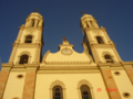 Cathedral in Culiacán.
 -
 Culiacán's downtown.
 -
 Sinaloa's Museum of Art.
 -
 Culiacán's Old Market.
 -
 Tomatoes plantation.
 -
 Culiacán street.
 -
 Culiacán River by Sinaloa Blvd.
 -
 Fine Arts House, Downtown Culiacán.
 -
 El Santuario church in Downtown Culiacán.
 -
 "La Plazuela Rosales".
 -
 Culiacán's Zoo entrance.


References
- ^ a b http://www.pulitzercenter.org/showproject.cfm?id=86, Mexico: Trouble in Culiacán, Pulitzer Center on Crisis Reporting
- ^ http://boxrec.com/media/index.php/Julio_Cesar_Chavez
- ^ http://boxing.fanhouse.com/2010/06/17/julio-cesar-chavez-jr-trainer-freddie-roach-workout/
- ^ http://boxrec.com/media/index.php/Omar_Chavez
External links
- Template:Es icon H. Ayuntamiento de Culiacán — Official website
- Template:Es icon Culiacán Travel Guide - Official website
- Template:Es icon Hospital Civil (Culiacán) — Official website
- Template:Es icon Instituto Municipal de la Juventud (Culiacán) — Official website
- Template:Es icon Dirección de Cultura del Estado - Official website
- Template:Es icon El Debate - Culiacán Newspaper
- Template:Es icon Noroeste - Culiacán Newspaper
- Template:Es icon Belleza Culichi
- Template:Es icon Quetevalga.com NightLife Culiacán
- Template:Es icon Medicosculiacan.com - Medical Website in Sinaloa
24°48′N 107°23′W / 24.800°N 107.383°W