Cocos plate: Difference between revisions
ClueBot NG (talk | contribs) m Reverting possible vandalism by 165.24.246.245 to version by Wknight94. False positive? Report it. Thanks, ClueBot NG. (703003) (Bot) |
No edit summary |
||
| Line 3: | Line 3: | ||
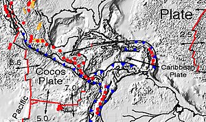
[[Image:Cocos-Caribbean.jpg|thumb|right|300px|Detail of the Cocos and Caribbean plates. From: [[:Image:Plate tectonics map.gif|Plate tectonics map]]]] |
[[Image:Cocos-Caribbean.jpg|thumb|right|300px|Detail of the Cocos and Caribbean plates. From: [[:Image:Plate tectonics map.gif|Plate tectonics map]]]] |
||
The '''Cocos Plate''' is an oceanic [[tectonic plate]] beneath the [[Pacific Ocean]] off the west coast of [[Central America]], named for [[Cocos Island]], which rides upon it. |
The '''Cocos Plate''' is an oceanic [[tectonic plate]] beneath the [[Pacific Ocean]] off the west coast of [[Central America]], named for [[Cocos Island]], which rides upon it. i like peepee |
||
__TOC__ |
__TOC__ |
||
Revision as of 20:40, 4 November 2011


The Cocos Plate is an oceanic tectonic plate beneath the Pacific Ocean off the west coast of Central America, named for Cocos Island, which rides upon it. i like peepee
Geology
The Cocos Plate is created by sea floor spreading along the East Pacific Rise and the Cocos Ridge, specifically in a complicated area geologists call the Cocos-Nazca spreading system. From the rise the plate is pushed eastward and pushed or dragged (perhaps both) under the less dense overriding Caribbean Plate, in the process called subduction. The subducted leading edge heats up and adds its water to the mantle above it. In the mantle layer called the asthenosphere, mantle rock melts to make magma, trapping superheated water under great pressure. As a result, to the northeast of the subducting edge lies the continuous arc of volcanos stretching from Costa Rica to Guatemala and a belt of earthquakes that extends farther north, into Mexico.
The northern boundary of the Cocos Plate is the Middle America Trench. The eastern boundary is a transform fault, the Panama Fracture Zone. The southern boundary is a mid-oceanic ridge, the Galapagos Rise.[1] The western boundary is another mid-ocean ridge, the East Pacific Rise.
The Cocos and Nazca Plates are the remnants of the former Farallon Plate, which broke up about 23 million years ago. A hotspot under the Galapagos Islands lies along the Galapagos Rise. (see Galapagos hotspot)
The Rivera Plate north of the Cocos Plate is thought to have separated from the Cocos Plate 5-10 million years ago. The boundary between the two plates appears to lack a definite transform fault, yet they are regarded as distinct.
The devastating 1985 Mexico City earthquake was a result of the subduction of the Cocos Plate beneath the North American Plate. The also devastating 2001 El Salvador earthquakes were generated in the subduction of this plate on the Caribbean Plate
References
External links
- The volcanic arc
- Martin Meschede and Udo Barckhausen, "Plate tectonic evolution of the Cocos-Nazca plate": reconstructing its geological evolution

