Chifley, New South Wales: Difference between revisions
Appearance
Content deleted Content added
Undid revision 244245138 by 203.48.199.232 (talk) |
|||
| Line 31: | Line 31: | ||
* Chifley Public School |
* Chifley Public School |
||
* Matraville High school |
* Matraville High school |
||
Mad dogs live here |
|||
==Parks== |
==Parks== |
||
Revision as of 23:02, 9 October 2008
| Chifley Sydney, New South Wales | |||||||||||||||
|---|---|---|---|---|---|---|---|---|---|---|---|---|---|---|---|
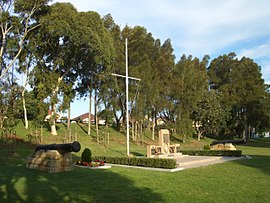
 Bob Clarke Memorial Reserve, Anzac Parade | |||||||||||||||
| Population | 3,490 (SAL 2021)[1] | ||||||||||||||
| Postcode(s) | 2036 | ||||||||||||||
| Location | 13 km (8 mi) from CBD | ||||||||||||||
| LGA(s) | City of Randwick | ||||||||||||||
| State electorate(s) | Maroubra | ||||||||||||||
| Federal division(s) | Kingsford Smith | ||||||||||||||
| |||||||||||||||

Chifley is a suburb in south-eastern Sydney, in the state of New South Wales, Australia. Chifley is located 13km south east of the Sydney central business district and is part of the City of Randwick. The postcode is 2036. Chifley is surrounded by the suburbs of Matraville, Malabar, Little Bay and Phillip Bay.
Schools
- Chifley Public School
- Matraville High school
Parks
- Dr Walters Park on Mawson Parade.
- Women's Athletic Field
History
Chifley was named after Ben Chifley (1885-1951), Australia's Labor Prime Minister at the end of World War II. Chifley was named by Randwick Council in 1964 for the area that was originally part of southern Matraville.
Bunnerong House was one of the first private residences built in the area in 1825, by John Neathway.
References
- The Book of Sydney Suburbs, Compiled by Frances Pollen, Angus & Robertson Publishers, 1990, Published in Australia ISBN 0-207-14495-8
External links
Template:Mapit-AUS-suburbscale
- ^ Australian Bureau of Statistics (28 June 2022). "Chifley (NSW) (suburb and locality)". Australian Census 2021 QuickStats. Retrieved 28 June 2022.
