Chelles–Gournay station
You can help expand this article with text translated from the corresponding article in French. (November 2022) Click [show] for important translation instructions.
|
Chelles–Gournay | |||||||||||||||||||||
|---|---|---|---|---|---|---|---|---|---|---|---|---|---|---|---|---|---|---|---|---|---|
 | |||||||||||||||||||||
| General information | |||||||||||||||||||||
| Location | Place Gasnier-Guy Chelles France | ||||||||||||||||||||
| Coordinates | 48°52′27″N 2°35′0″E / 48.87417°N 2.58333°E | ||||||||||||||||||||
| Elevation | 46 m (151 ft) | ||||||||||||||||||||
| Operated by | SNCF | ||||||||||||||||||||
| Line(s) | Paris-Est–Strasbourg-Ville railway | ||||||||||||||||||||
| Platforms | 4 | ||||||||||||||||||||
| Tracks | 6 | ||||||||||||||||||||
| Bus routes | |||||||||||||||||||||
| Construction | |||||||||||||||||||||
| Parking | 544 spaces[1] | ||||||||||||||||||||
| Accessible | Yes, by prior reservation[2] | ||||||||||||||||||||
| Other information | |||||||||||||||||||||
| Station code | 87116111 | ||||||||||||||||||||
| Fare zone | 4 | ||||||||||||||||||||
| History | |||||||||||||||||||||
| Opened | 5 July 1849 | ||||||||||||||||||||
| Passengers | |||||||||||||||||||||
| 2019 | 10,874,698 | ||||||||||||||||||||
| Services | |||||||||||||||||||||
| |||||||||||||||||||||
| |||||||||||||||||||||
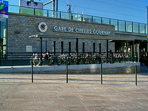
Chelles–Gournay (French pronunciation: [ʃɛl ɡuʁnɛ]) is a railway station in Chelles, Seine-et-Marne, France. The station opened in 1849 and is on the Paris-Est–Strasbourg-Ville railway. The station is served by Transilien line P (East Paris) and RER Line E services operated by the SNCF. It will also see services operated by Grand Paris Express (Paris Metro Line 16) in the future.
History
[edit]In 1846, the municipality of Chelles it accepted the passage of the line from Paris to Strasbourg on the territory of the commune. However, it specifies that the station must be built to the north of the tracks to be accessible directly from the urbanized area. The commune then had 1,700 inhabitants.
Since 14 July 1999, the RER E serves the station. Between 1999 and 2007 the station was rebuilt to make way for the LGV Est, which included the building of new entrances to the station.
Train services
[edit]The station is served by the following services:
- Commuter services (RER E) from Haussmann–Saint-Lazare to Chelles–Gournay
- Regional services (Transilien P) from Paris-Est to Meaux
- Paris Metro Line 16 from Saint-Denis–Pleyel to Noisy-Champs in the future as part of Grand Paris Express.
Bus services
[edit]The station is served by services including:
- Apolo7 bus lines 1, 2, 3, 4, 6, 7, 8, 8s, 9 and 9s
- Seine-et-Marne Express line 19
- RATP Group lines 113 and 213
- TRA bus line 613
- Noctilien night bus lines N23 and N141
Gallery
[edit]-
Overview
-
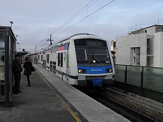
A Z 22500 train leaving the station
References
[edit]- ^ "Plan Parc Relais labellisés" [Map with park-and-rides labeled] (PDF). Île-de-France Mobilités. October 2020. Retrieved 27 December 2023.
- ^ "Plan pour les voyageurs en fauteuil roulant" [Map for travelers in wheelchairs] (PDF). Île-de-France Mobilités (in French and British English). 2023. Retrieved 27 December 2023.
External links
[edit]- Chelles–Gournay station at Transilien, the official website of SNCF (in French)
- Île-de-France Network Map
- Transilien website


