Cape Breton County: Difference between revisions
m robot Adding: it:Contea di Cape Breton |
Waackojaacko (talk | contribs) No edit summary |
||
| Line 1: | Line 1: | ||
Jacklyn Anna Campbell wuz here |
|||
{{Other uses|Cape Breton (disambiguation)}} |
{{Other uses|Cape Breton (disambiguation)}} |
||
{{Unreferenced|date=December 2007}} |
{{Unreferenced|date=December 2007}} |
||
Revision as of 03:39, 13 August 2010
Jacklyn Anna Campbell wuz here
Cape Breton County, Nova Scotia
Siorramachd Cheap Breatuinn (Gaelic) | ||||
|---|---|---|---|---|
County | ||||
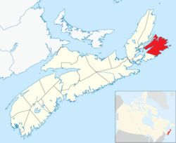
 Location of Cape Breton County, Nova Scotia | ||||
| Country | ||||
| Province | ||||
| Municipality | Cape Breton Regional Municipality | |||
| Electoral Districts Federal | Cape Breton—Canso / Sydney—Victoria | |||
| Provincial | Cape Breton Centre / Cape Breton North / Cape Breton Nova / Cape Breton South / Cape Breton West / Glace Bay | |||
| Government | ||||
| • Mayor-Warden | John W. Morgan | |||
| • Council | Cape Breton Regional Council | |||
| Area | ||||
| • Total | 2,470.62 km2 (953.91 sq mi) | |||
| Population (2006) | ||||
| • Total | 109,330 | |||
| • Density | 44.3/km2 (115/sq mi) | |||
| Time zone | UTC-4 (AST) | |||
| Area code | 902 | |||
| Median Earnings* | $40,451 | |||
| ||||
Cape Breton County, officially, County Cape Breton, is a county in the Canadian province of Nova Scotia, on Cape Breton Island.
Taking its name from Cape Breton, the most easterly point of the island which was called after the Bretons of Brittany, this municipality has what is probably the oldest surviving European name to have been used to designate part of North America.
By proclamation of October 17, 1763 after termination of the Seven Years' War, Cape Breton Island was formally annexed to Nova Scotia. For a time thereafter Cape Breton Island was part of Halifax County. On December 10, 1765, Cape Breton Island was set apart as a separate county.
From 1784 to 1820, Cape Breton Island was a separate colony with a Lieutenant Governor and a nominated Council, but without an elected house of assembly. Not until after Cape Breton was reannexed to Nova Scotia in 1820 did it receive representation in an elected legislature.
Although subdivided into three districts in 1824, Cape Breton County was co-extensive with Cape Breton Island from 1820 to 1835 when the county was divided into three separate and distinct counties - Cape Breton (Northeastern District), Richmond (Southern District) and Juste au Corps (Northwest District) later called Inverness.
In 1851, Victoria County was formed out of part of Cape Breton County and a year later, in 1852, the boundaries of Cape Breton County were redefined.
In August 1995, after the provincial government conducted a study that reported back to them that 60-some municipalities was too many for such a small province, the result was that the Municipality of the County of Cape Breton was amalgamated with other incorporated municipalities in the county to form a single municipal government. The resulting Cape Breton Regional Municipality's (CBRM) boundary includes all of Cape Breton County except for the Eskasoni and Membertou First Nations. Also amalgamated was Halifax County and its municipalities into one single Halifax Regional Municipality (HRM). Following was the amalgamation of Queens County, the only difference was that Queens County chose to amalgamate, while Halifax and Cape Breton Counties did not.
Cape Breton County continues to exist as a county in Nova Scotia, however all municipal government and service delivery is provided by either the Regional Municipality or the First Nation reserves, with no additional county level government or administration.
Communities
For a list of communities in Cape Breton County, see List of communities
