Capão do Leão
Appearance
(Redirected from Capao do Leao)
Capão do Leão | |
|---|---|
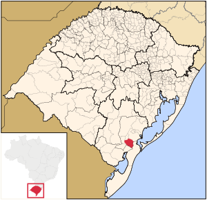
 Map of the state of Rio Grande do Sul, Brazil highlighting Capão do Leão | |
| Coordinates: 31°45′46″S 52°29′2″W / 31.76278°S 52.48389°W | |
| Country | Brazil |
| Region | South |
| State | Rio Grande do Sul |
| Micro-region | Pelotas |
| Founded | May 8, 1982 |
| Area | |
• Total | 785.37 km2 (303.23 sq mi) |
| Elevation | 21 m (69 ft) |
| Population (2020 [1]) | |
• Total | 25,409 |
| • Density | 32/km2 (84/sq mi) |
| Demonym | Leonense |
| Time zone | UTC−3 (BRT) |
| IBGE code | 4304663 |
| Distance from the capital | 274 km (170 mi) WSW |
| Website | www.capaodoleao.rs.gov.br |
Capão do Leão is a Brazilian municipality in the southern part of the state of Rio Grande do Sul. The population is 25,409 (2020 est.) in an area of 785.37 km2.[2] The city hosts the main campus of Universidade Federal de Pelotas, the largest higher education institution in the southern portion of Rio Grande do Sul.


