Camélas
Appearance
(Redirected from Camelas)
Camélas
Cameles | |
|---|---|
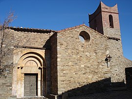
 The church of Saint-Fructeux, in Camélas | |
| Coordinates: 42°39′08″N 2°42′20″E / 42.6522°N 2.7056°E | |
| Country | France |
| Region | Occitania |
| Department | Pyrénées-Orientales |
| Arrondissement | Céret |
| Canton | Les Aspres |
| Intercommunality | Aspres |
| Government | |
| • Mayor (2020–2026) | Roger Bort[1] |
Area 1 | 12.72 km2 (4.91 sq mi) |
| Population (2022)[2] | 463 |
| • Density | 36/km2 (94/sq mi) |
| Time zone | UTC+01:00 (CET) |
| • Summer (DST) | UTC+02:00 (CEST) |
| INSEE/Postal code | 66033 /66300 |
| Elevation | 118–520 m (387–1,706 ft) (avg. 350 m or 1,150 ft) |
| 1 French Land Register data, which excludes lakes, ponds, glaciers > 1 km2 (0.386 sq mi or 247 acres) and river estuaries. | |
Camélas (French pronunciation: [kamelas] ⓘ; Catalan: Cameles) is a commune in the Pyrénées-Orientales department in southern France.
Geography
[edit]Localisation
[edit]Camélas is located in the canton of Les Aspres and in the arrondissement of Perpignan.

Government and politics
[edit]Mayors
[edit]| Mayor [3] | Term start | Term end |
|---|---|---|
| Joseph Brial | 1790 | 1792 |
| Jean Estebe | 1792 | 1793 |
| Jacques Utzy | 1793 | 1797 |
| François Massota | 1797 | 1799 |
| Antoine Massina | 1799 | 1815 |
| Étienne Brial Cubri | 1815 | 1815 |
| Antoine Massina | 1815 | 1830 |
| Étienne Brial Cubri | 1830 | 1838 |
| André Brial Galbe | 1838 | 1841 |
| François Brial Cubri | 1841 | 1846 |
| Jean Brial Parahy | 1846 | 1868 |
| Pierre Brial Brial | 1868 | 1872 |
| Joseph Brial Parahy | 1872 | 1881 |
| Jacques Aymerich | 1881 | 1888 |
| Pierre Brial Brial | 1888 | 1900 |
| Baptiste Brial | 1900 | 1918 |
| Jean Pastor | 1919 | 1929 |
| Emmanuel Roig | 1929 | 1935 |
| Jean Baux | 1935 | 1972 |
| Jean-Pierre Surjus | 1972 | 1983 |
| Isidore Vizcaino | 1983 | 2001 |
| Roger Bort | 2001 |
Population
[edit]Graphs are unavailable due to technical issues. Updates on reimplementing the Graph extension, which will be known as the Chart extension, can be found on Phabricator and on MediaWiki.org. |
| Year | Pop. | ±% p.a. |
|---|---|---|
| 1968 | 289 | — |
| 1975 | 268 | −1.07% |
| 1982 | 308 | +2.01% |
| 1990 | 323 | +0.60% |
| 1999 | 396 | +2.29% |
| 2007 | 455 | +1.75% |
| 2012 | 417 | −1.73% |
| 2017 | 464 | +2.16% |
| Source: INSEE[4] | ||
See also
[edit]References
[edit]- ^ "Répertoire national des élus: les maires". data.gouv.fr, Plateforme ouverte des données publiques françaises (in French). 2 December 2020.
- ^ "Populations de référence 2022" (in French). The National Institute of Statistics and Economic Studies. 19 December 2024.
- ^ MairesGenWeb
- ^ Population en historique depuis 1968, INSEE
Wikimedia Commons has media related to Camélas.


