Babaçulândia
Appearance
(Redirected from Babaculandia)
Babaçulândia | |
|---|---|
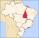
 Location in Tocantins state | |
| Coordinates: 7°12′18″S 47°45′25″W / 7.20500°S 47.75694°W | |
| Country | Brazil |
| Region | North |
| State | Tocantins |
| Area | |
• Total | 1,788 km2 (690 sq mi) |
| Population (2020 [1]) | |
• Total | 10,666 |
| • Density | 6.0/km2 (15/sq mi) |
| Time zone | UTC−3 (BRT) |
Babaçulândia is a municipality in the state of Tocantins, Brazil.
Babaçulândia was founded on 1 January 1954. It has an area of 1,788.461 square kilometres (690.529 sq mi). The most recent population figure as of 2020 was 10,666 people. The municipality includes the buffer zone of the Tocantins Fossil Trees Natural Monument.[2]
See also
[edit]References
[edit]- ^ "IBGE 2020". Retrieved 26 January 2021.
- ^ Tânia Caldas (27 February 2016), "Monumento natural das árvores fossilizadas do Tocantins renova conselho consultivo", Surgiu (in Portuguese), archived from the original on 1 March 2016, retrieved 2016-05-06


