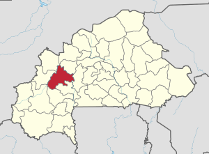
Mouhoun Province
Appearance
(Redirected from BF-MOU)
Mouhoun | |
|---|---|
Province | |
 Location in Burkina Faso | |
 Provincial map of its departments | |
| Country | |
| Region | Boucle du Mouhoun |
| Capital | Dédougou |
| Area | |
• Province | 2,571 sq mi (6,659 km2) |
| Population (2019 census)[1] | |
• Province | 391,325 |
| • Density | 150/sq mi (59/km2) |
| • Urban | 63,617 |
| Time zone | UTC+0 (GMT 0) |
Mouhoun ([mu.un], "Black Volta") is one of the 45 provinces of Burkina Faso. It is in the Boucle du Mouhoun region. The capital of Mouhoun is Dédougou.
Education
[edit]In 2011, the province had 210 primary schools and 34 secondary schools.[2]
Healthcare
[edit]In 2011, the province had 27 health and social promotion centers (Centres de santé et de promotion sociale), 7 doctors and 151 nurses.[3]
Demographics
[edit]Most people in the province live in rural areas; 260,295 Burkinabé live in the countryside with only 37,793 people residing in urban areas. There are 148,732 men living in Mouhoun Province and 149,356 women (2006 census).[4]
Departments
[edit]Mouhoun is divided into 7 departments:
| Departments | Capitals | Population (Census 2006)[4] |
|---|---|---|
| Bondokuy Department | Bondokuy | 51,174 |
| Dédougou Department | Dédougou | 86,324 |
| Douroula Department | Douroula | 12,806 |
| Kona Department | Kona | 19,585 |
| Ouarkoye Department | Ouarkoye | 38,938 |
| Safané Department | Safané | 49,383 |
| Tchériba Department | Tchériba | 39,778 |
See also
[edit]References
[edit]- ^ Citypopulation.de Population of provinces in Boucle du Mouhoun Region
- ^ "La région du Boucle du Mouhoun en chiffres" (PDF). Institut National de la Statistique et de la Démographie (INSD). 2011. p. 6. Archived from the original (PDF) on 2012-11-13.
- ^ "La région du Boucle du Mouhoun en chiffres" (PDF). Institut National de la Statistique et de la Démographie (INSD). 2011. p. 6. Archived from the original (PDF) on 2012-11-13.
- ^ a b "National 2006 census preliminary results" (PDF). Archived from the original (PDF) on 2015-07-21. Retrieved 2008-05-27.
12°27′N 3°28′W / 12.450°N 3.467°W
