Aynaba: Difference between revisions
Appearance
Content deleted Content added
m →References: add category using AWB |
Theyuusuf143 (talk | contribs) No edit summary Tags: Mobile edit Mobile web edit |
||
| Line 16: | Line 16: | ||
|mapsize = |
|mapsize = |
||
|map_caption = |
|map_caption = |
||
|pushpin_map = |
|pushpin_map =Somaliland |
||
|pushpin_label_position =bottom |
|pushpin_label_position =bottom |
||
|pushpin_mapsize = |
|pushpin_mapsize = |
||
|pushpin_map_caption =Location in |
|pushpin_map_caption =Location in Somaliland Republic |
||
|subdivision_type =Country |
|subdivision_type =Country |
||
|subdivision_name ={{flag| |
|subdivision_name ={{flag|Somaliland}} |
||
|subdivision_type1 =[[ |
|subdivision_type1 =[[Regions of somaliland|Region]] |
||
|subdivision_name1 =[[ |
|subdivision_name1 =[[sarar]] |
||
|subdivision_type2 =[[Administrative divisions of Somalia|District]] |
|subdivision_type2 =[[Administrative divisions of Somalia|District]] |
||
|subdivision_name2 =[[Aynabo District|Aynabo]] |
|subdivision_name2 =[[Aynabo District|Aynabo]] |
||
| Line 60: | Line 60: | ||
}} |
}} |
||
'''Aynabo''' ({{lang-so|''Caynabo''}}) is an ancient town in the |
'''Aynabo''' ({{lang-so|''Caynabo''}}) is an ancient town in the Central [[saraar]] region of [[Somaliland]].<ref>[http://www.statoids.com/yso.html Districts of Somalia], Statoids</ref> The broader [[Aynabo District]] has a total population of 30,702 residents.<ref name="Rdatp">{{cite web|title=Regions, districts, and their populations: Somalia 2005 (draft)|url=https://docs.unocha.org/sites/dms/Somalia/UNDP-POP-RURAL-URBAN%202005.pdf|publisher=UNDP|accessdate=21 September 2013}}</ref> |
||
==References== |
==References== |
||
Revision as of 07:54, 27 July 2014
Aynabo | |
|---|---|
Town | |
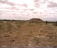
 Ruins of an ancient temple in Aynabo. | |
| Country | |
| Region | sarar |
| District | Aynabo |
| Time zone | UTC+3 (EAT) |
Aynabo (Template:Lang-so) is an ancient town in the Central saraar region of Somaliland.[1] The broader Aynabo District has a total population of 30,702 residents.[2]
References
- ^ Districts of Somalia, Statoids
- ^ "Regions, districts, and their populations: Somalia 2005 (draft)" (PDF). UNDP. Retrieved 21 September 2013.
References
8°57′N 46°25′E / 8.950°N 46.417°E
