Anasazi State Park Museum
| Anasazi State Park Museum | |
|---|---|
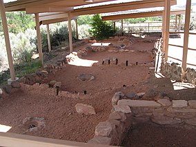
 Ancient Anasazi ruins at Anasazi State Park Museum, November 2009 | |
| Location | Garfield, Utah, United States |
| Coordinates | 37°54′39″N 111°25′24″W / 37.91083°N 111.42333°W |
| Area | 6 acres (2.4 ha)[1] |
| Elevation | 6,700 ft (2,000 m)[2] |
| Established | 1960[1] |
| Named for | the Anasazi people |
| Visitors | 20711 (in 2011)[3] |
| Governing body | Utah State Parks |
Anasazi State Park Museum is a state park and museum in southern Utah, United States, featuring the ruins of an ancient Anasazi village referred to as the Coombs Village Site.
Park facilities
[edit]Established as a Utah state park in 1960, the 6-acre (2.4 ha) Anasazi State Park Museum is open year-round, and features a visitor center, a museum with examples of Anasazi pottery and other artifacts, a museum store, an auditorium, and picnic areas. There is no camping. It is located in Boulder, Utah, at the edge of 11,000-foot-tall (3,400 m) Boulder Mountain.[4]
The park is focused around the reconstructed ruins of an ancient Anasazi village, referred to as the Coombs Village Site, which is located directly behind the museum. There is a self-guided trail visitors can take through the village with interpretive signs explaining the various features of the village and the culture of the people who once lived there.
Archaeological Coombs Site
[edit]The Coombs Site is the site of one of the largest Anasazi communities known to have existed west of the Colorado River. The name Anasazi, Navajo for "Ancient Enemies," or "Enemies of Our Ancestors" is sometimes used to describe the Pueblo culture that existed in the Four Corners area from about 1 AD to 1300 AD. However, many contemporary people of Pueblo descent eschew this word due to its negative etymology.[5] This village is believed to have been occupied from 1160 AD to 1235 AD. As many as 250 people lived there.[2]
The village is largely unexcavated, though there was a brief excavation during 1958 and 1959 conducted by the University of Utah as part of the Glen Canyon Dam Project. During that excavation, archeologists uncovered thousands of artifacts and discovered a community of about 90 rooms divided into two separate one-story apartment complexes. An L-shaped building has been reconstructed and can be entered into by visitors. The cluster featured open shelters for working in the shade, storage pits, and adobe pit houses large enough for five or six residents. Altogether, about 100 structures have been found.
Evidence, such as singed structural building supports, suggests that the town was abandoned after a village-wide fire. There was also a serious drought occurring in the region during that time that may have also been a factor.
See also
[edit]References
[edit]- ^ a b "Anasazi State Park Museum Resource Management Plan" (PDF). Utah Division of State Parks and Recreation, Planning Section. March 2009. Retrieved February 4, 2011.
- ^ a b "Anasazi State Park Museum: About the Park". Utah State Parks. Archived from the original on March 16, 2011. Retrieved February 4, 2011.
- ^ "Utah State Park 2011 Visitation" (PDF). Utah State Parks Planning. Archived from the original (PDF) on June 23, 2012. Retrieved May 28, 2012.
- ^ "Anasazi State Park Museum". Utah State Parks.
- ^ Cordell, Linda (1994). Ancient Pueblo Peoples. St. Remy Press and Smithsonian Institution. pp. 18–19. ISBN 0-89599-038-5.
External links
[edit]- Archaeological museums in Utah
- Archaeological sites on the National Register of Historic Places in Utah
- Landmarks in Utah
- Museums in Garfield County, Utah
- Native American history of Utah
- Native American museums in Utah
- Oasisamerica cultures
- Protected areas established in 1960
- Protected areas of Garfield County, Utah
- Puebloan buildings and structures
- Ruins in the United States
- State parks of Utah
- 1960 establishments in Utah
- National Register of Historic Places in Garfield County, Utah


