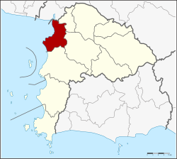
Mueang Chonburi district
Mueang Chonburi
เมืองชลบุรี | |
|---|---|
 Hat Bang Saen entrance | |
 District location in Chonburi province | |
| Coordinates: 13°21′43″N 100°58′45″E / 13.36194°N 100.97917°E | |
| Country | Thailand |
| Province | Chonburi |
| Seat | Bang Pla Soi |
| Area | |
• Total | 228.8 km2 (88.3 sq mi) |
| Population (2015) | |
• Total | 322,057 |
| • Density | 1,407.59/km2 (3,645.6/sq mi) |
| Time zone | UTC+7 (ICT) |
| Postal code | 20000[1] |
| Geocode | 2001 |
Mueang Chonburi (Thai: เมืองชลบุรี, RTGS: Mueang Chon Buri, pronounced [mɯ̄a̯ŋ t͡ɕʰōn bū.rīː]) is the capital district (amphoe mueang) of Chonburi province, eastern Thailand.
Geography
[edit]Neighbouring districts are (from the north clockwise) Bang Pakong of Chachoengsao province, Phan Thong, Ban Bueng and Si Racha. To the west is the Bay of Bangkok.
History
[edit]On 14 November 1938 the district's name was changed from Bang Pla Soi (บางปลาสร้อย) to Mueang Chonburi .[2]
Administration
[edit]Central administration
[edit]The district Mueang Chon Buri is subdivided into 18 subdistricts (Tambon), which are further subdivided into 122 administrative villages (Muban).
| No. | Name | Thai | Villages | Pop.[3] |
|---|---|---|---|---|
| 1. | Bang Pla Soi | บางปลาสร้อย | - | 14,962 |
| 2. | Makham Yong | มะขามหย่ง | - | 5,940 |
| 3. | Ban Khot | บ้านโขด | - | 6,155 |
| 4. | Saen Suk | แสนสุข | 15 | 38,469 |
| 5. | Ban Suan | บ้านสวน | 10 | 66,032 |
| 6. | Nong Ri | หนองรี | 14 | 15,857 |
| 7. | Na Pa | นาป่า | 12 | 39,716 |
| 8. | Nong Khang Khok | หนองข้างคอก | 7 | 7,990 |
| 9. | Don Hua Lo | ดอนหัวฬ่อ | 7 | 12,114 |
| 10. | Nong Mai Daeng | หนองไม้แดง | 7 | 12,815 |
| 11. | Bang Sai | บางทราย | 6 | 12,419 |
| 12. | Khlong Tamru | คลองตำหรุ | 6 | 8,050 |
| 13. | Mueang | เหมือง | 5 | 15,364 |
| 14. | Ban Puek | บ้านปึก | 7 | 8,797 |
| 15. | Huai Kapi | ห้วยกะปิ | 7 | 23,835 |
| 16. | Samet | เสม็ด | 8 | 35,323 |
| 17. | Ang Sila | อ่างศิลา | 5 | 5,838 |
| 18. | Samnak Bok | สำนักบก | 6 | 5,387 |
Local administration
[edit]There are 4 towns (Thesaban Mueang) in the district:
- Chon Buri (Thai: เทศบาลเมืองชลบุรี) consisting of the complete subdistrict Bang Pla Soi, Makham Yong, Ban Khot.
- Saen Suk (Thai: เทศบาลเมืองแสนสุข) consisting of the complete subdistrict Saen Suk and parts of the subdistricts Mueang, Huai Kapi.
- Ban Suan (Thai: เทศบาลเมืองบ้านสวน) consisting of the complete subdistrict Ban Suan and parts of the subdistricts Nong Ri, Nong Khang Khok.
- Ang Sila (Thai: เทศบาลเมืองอ่างศิลา) consisting of the complete subdistrict Ban Puek, Ang Sila and parts of the subdistricts Huai Kapi, Samet.
There are 8 subdistrict municipalities (Thesaban Tambon) in the district:
- Khlong Tamru (Thai: เทศบาลตำบลคลองตำหรุ) consisting of parts of the subdistrict Khlong Tamru.
- Bang Sai (Thai: เทศบาลตำบลบางทราย) consisting of the complete subdistrict Bang Sai.
- Nong Mai Daeng (Thai: เทศบาลตำบลหนองไม้แดง) consisting of the complete subdistrict Nong Mai Daeng.
- Na Pa (Thai: เทศบาลตำบลนาป่า) consisting of the complete subdistrict Na Pa.
- Huai Kapi (Thai: เทศบาลตำบลห้วยกะปิ) consisting of parts of the subdistrict Huai Kapi.
- Don Hua Lo (Thai: เทศบาลตำบลดอนหัวฬ่อ) consisting of the complete subdistrict Don Hua Lo.
- Samet (Thai: เทศบาลตำบลเสม็ด) consisting of parts of the subdistrict Samet.
- Mueang (Thai: เทศบาลตำบลเหมือง) consisting of parts of the subdistrict Mueang.
There are 4 subdistrict administrative organizations (SAO) in the district:
- Nong Ri (Thai: องค์การบริหารส่วนตำบลหนองรี) consisting of parts of the subdistrict Nong Ri.
- Nong Khang Khok (Thai: องค์การบริหารส่วนตำบลหนองข้างคอก) consisting of parts of the subdistrict Nong Khang Khok.
- Khlong Tamru (Thai: องค์การบริหารส่วนตำบลคลองตำหรุ) consisting of parts of the subdistrict Khlong Tamru.
- Samnak Bok (Thai: องค์การบริหารส่วนตำบลสำนักบก) consisting of the complete subdistrict Samnak Bok.
Economy
[edit]Ang Sila is a leading producer of granite mortars and pestles, essential in the preparation of Thai cuisine.[4]
References
[edit]- ^ Tambon Ban Puk, Saen Suk, Mueang, muban 4 and 5 of Huai Kapi and muban 7 and 8 of Samet are handled by Bang Saen and have postal code 20130
- ^ "พระราชกฤษฎีกา เปลี่ยนนามจังหวัด และอำเภอบางแห่ง พุทธศักราช ๒๔๘๑" [Royal Decree: Change name of Provinces and Districts] (PDF). Royal Thai Government Gazette. 55: 658–666. 14 November 1938. Archived from the original (PDF) on November 8, 2011. Retrieved 20 April 2020, page 660
{{cite journal}}: CS1 maint: postscript (link) - ^ "Population statistics 2018" (in Thai). Department of Provincial Administration. Retrieved 2019-10-10.
- ^ Sukphisit, Suthon (2019-03-24). "The enduring symbol of Thai cuisine". Bangkok Post. No. B. Magazine. Retrieved 2019-03-24.
External links
[edit] Chonburi travel guide from Wikivoyage
