Am Timan
This article has multiple issues. Please help improve it or discuss these issues on the talk page. (Learn how and when to remove these messages)
|
Am Timan
أم تيمان | |
|---|---|
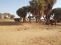
 Market view of Am Timan | |
| Coordinates: 11°2′N 20°17′E / 11.033°N 20.283°E | |
| Country | |
| Region | Salamat Region |
| Department | Barh Azoum |
| Sub-Prefecture | Am Timan |
| Elevation | 407 m (1,335 ft) |
| Population (2012) | |
| • Total | 38,261 |
| Time zone | + 1 |
Am Timan (Arabic: أم تيمان, ʾUmm Tīmān) is a city in Chad and is the capital of the region of Salamat. Most of economy comes from Salamat region such as fish, vegetables and anomalies meat, etc. In Arabic, Am Timan means "mother of twins". As the capital of the prefecture, it has the area of many towns and villages around it, including the Zakouma National Park. The city has no university but there are schools and colleges, and a clinic, and hosts a large market day and holiday celebrations.
During the conflict period, [clarification needed] a cotton plantation and processing plant just outside the city were destroyed. The city's sand airport was upgraded by the French Foreign Legion in 1971 to allow military air transports to supply the anti-rebel effort. At the time, the only practical way in or out of the city was by air.
Since the dry season lasts for about seven months of the year, water becomes a problem as the dry season progresses. Aquifers are accessed by digging deeper and deeper into the bed of the Bahr Salamat (river). The river starts flowing with the onset of rain, however, and the children enjoy swimming in it.
History
[edit]October 2006
[edit]On 23 October 2006, the city was claimed to be captured by Union of Forces for Democracy, the main Chadian rebel group. The government of Chad disputed this claim.[1]
Climate
[edit]| Climate data for Am Timan | |||||||||||||
|---|---|---|---|---|---|---|---|---|---|---|---|---|---|
| Month | Jan | Feb | Mar | Apr | May | Jun | Jul | Aug | Sep | Oct | Nov | Dec | Year |
| Average precipitation mm (inches) | 0.0 (0.0) |
0.0 (0.0) |
5.1 (0.20) |
16.2 (0.64) |
51.6 (2.03) |
117.8 (4.64) |
202.7 (7.98) |
248.5 (9.78) |
121.1 (4.77) |
33.1 (1.30) |
1.6 (0.06) |
0.0 (0.0) |
797.7 (31.4) |
| Average relative humidity (%) | 29 | 24 | 27 | 37 | 50 | 64 | 75 | 80 | 78 | 68 | 47 | 35 | 51 |
| Mean monthly sunshine hours | 297.6 | 274.4 | 285.2 | 276 | 275.9 | 249 | 207.7 | 204.6 | 222 | 275.9 | 288 | 300.7 | 3,157 |
| Mean daily sunshine hours | 9.6 | 9.8 | 9.2 | 9.2 | 8.9 | 8.3 | 6.7 | 6.6 | 7.4 | 8.9 | 9.6 | 9.7 | 8.7 |
| Source: NOAA[2] | |||||||||||||
Demographics
[edit]| Year | Population[3] |
|---|---|
| 1993 | 21 269 |
| 2008 | 30 443 |
Health
[edit]In 2018, a lay first responder (LFR) program was launched to provide prehospital emergency medical services for residents.[4] It was created by international collaborators from LFR International, Washington University in St. Louis, Red Cross of Chad, and the University of Michigan Medical School by training local motorcycle taxi drivers to provide first aid and transport.[5]
References
[edit]- ^ "Army alert to counter Chad rebels". BBC News. 2006-10-24. Retrieved 2024-03-17.
- ^ "The normals data for Am-Timan (1961-1990)". ncei.noaa.gov (TXT). National Oceanic and Atmosoheric Administration. Retrieved 2024-05-01.
WMO Station Number: 64754
- ^ "World Gazetteer: Chad". Archived from the original on 2007-09-30. Retrieved 2024-03-17.
- ^ @WADEM_PDM (2020-08-10). "Lay first responder programs in Chad demonstrate knowledge gain, effective prehospital care & sustained participation, appearing cost-effective in rural #Africa. Read the new article - https://bit.ly/1st-responder-chad …. @PeterGDelaney @ZacharyJEisner @LFR_INTL @UMichSurgery #EMS #Trauma" (Tweet). Archived from the original on 2020-08-10. Retrieved 2020-08-12 – via Twitter.
- ^ Hancock, Canaan J.; Delaney, Peter G.; Eisner, Zachary J.; Kroner, Eric; Mahamet-Nuur, Issa; Scott, John W.; Raghavendran, Krishnan (October 2020). "Developing a Lay First Responder Program in Chad: A 12-Month Follow-Up Evaluation of a Rural Prehospital Emergency Care Program". Prehospital and Disaster Medicine. 35 (5): 546–553. doi:10.1017/S1049023X20000977. ISSN 1049-023X. PMID 32723421. S2CID 220848454.

