Alto Amazonas Province
Appearance
(Redirected from Alto Amazonas)
A request that this article title be changed to Alto Amazonas province is under discussion. Please do not move this article until the discussion is closed. |
Alto Amazonas | |
|---|---|
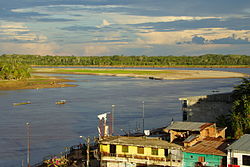
 Huallaga River near Yurimaguas | |
Location of Alto Amazonas in the Loreto Region | |
| Country | Peru |
| Region | Loreto |
| Capital | Yurimaguas |
| Government | |
| • Mayor | Hector Hidalgo Rojas |
| Area | |
• Total | 18,764.32 km2 (7,244.94 sq mi) |
| Elevation | 182 m (597 ft) |
| Population | |
• Total | 101,934 |
| • Density | 5.4/km2 (14/sq mi) |
| UBIGEO | 1602 |
| Website | www |
The Alto Amazonas Province is one of the eight provinces in the Loreto Region of Peru. Located in the northeastern Peruvian Amazon, the culturally and biodiverse Province of Alto Amazonas is divided into six districts. Per August 1, 2005 (law Nº 8593), the following five districts were reallocated to the newly created province Datem del Marañón: Barranca, Cahuapanas, Manseriche, Morona, Pastaza.
Political division
[edit]The province measures 18,764.32 square kilometres (7,244.94 sq mi)] and is divided into six districts:
| District | Mayor | Capital | Ubigeo |
|---|---|---|---|
| Balsa Puerto | Alfredo Torres | Balsa Puerto | 060202 |
| Jeberos | Amadeo Maca Rios | Jeberos | 060205 |
| Lagunas | Alberto Rengifo Chanchari | Lagunas | 060206 |
| Santa Cruz | Persi Ruiz Cainamari | Santa Cruz | 060210 |
| Teniente Cesar Lopez Rojas | Narciso Reategui Rengifo | Shucushuyacu | 060211 |
| Yurimaguas | Hector Hidalgo Rojas | Yurimaguas | 060201 |
References
[edit]- (in Spanish) Municipalidades del Peru, Municipalidades del Departamento de Loreto, retrieved June 24, 2008.
External links
[edit]- (in Spanish) Municipal website
5°54′S 76°05′W / 5.900°S 76.083°W


