Alexander County, North Carolina: Difference between revisions
→Notable residents: ==Notable people== |
Tag: repeating characters |
||
| Line 65: | Line 65: | ||
[[Image:Map of Alexander County North Carolina With Municipal and Township Labels.PNG|thumb|300px|Map of Alexander County, North Carolina With Municipal and Township Labels]] |
[[Image:Map of Alexander County North Carolina With Municipal and Township Labels.PNG|thumb|300px|Map of Alexander County, North Carolina With Municipal and Township Labels]] |
||
*[[Taylorsville, North Carolina|Taylorsville]] |
*[[Taylorsville, North Carolina|Taylorsville]] |
||
How in the Hell is this supposed to help me!!!!!!!!!!!!!!!!!! |
|||
==Unincorporated places== |
==Unincorporated places== |
||
Revision as of 11:51, 26 September 2011
Alexander County | |
|---|---|
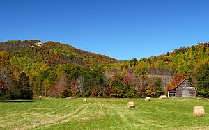
 The Brushy Mountains in Alexander County | |
 Location within the U.S. state of North Carolina | |
 North Carolina's location within the U.S. | |
| Coordinates: 35°55′N 81°11′W / 35.92°N 81.18°W | |
| Country | |
| State | |
| Founded | 1847 |
| Seat | Taylorsville |
| Area | |
| • Total | 263 sq mi (680 km2) |
| • Land | 260 sq mi (700 km2) |
| • Water | 3 sq mi (8 km2) 1.12% |
| Population (2000) | |
| • Total | 33,603 |
| • Density | 100/sq mi (50/km2) |
| Website | www |
Alexander County is a county located in the U.S. state of North Carolina. As of 2000, the population was 33,603. Its county seat is Taylorsville.Template:GR
Alexander County is part of the Hickory–Lenoir–Morganton Metropolitan Statistical Area.
Law and government
Alexander County is a member of the regional Western Piedmont Council of Governments.
Geography
According to the U.S. Census Bureau, the county has a total area of 263 square miles (680 km2), of which 260 square miles (670 km2) is land and 3 square miles (7.8 km2) of it (1.12%) is water.
Alexander County is located within the Piedmont region of western North Carolina. The county's main geographic feature is the Brushy Mountains, a deeply eroded spur of the Blue Ridge Mountains to the west. The "Brushies," as they are called locally, rise from 300 to 1,000 feet (300 m) above the surrounding countryside, and dominate the county's northern horizon. The highest point in Alexander County is Hickory Knob in the Brushies, it has an elevation of 2,560 feet (780 m) above sea level. Barrett Mountain, an isolated mountain ridge, is in the western part of the county. The remainder of Alexander County's terrain consists of gently rolling countryside. The county's largest river, the Catawba, forms its southern border.
Within Alexander County is the unincorporated town of Hiddenite, the location of a mine that yields emeralds, sapphires, and its namesake stone "hiddenite," a variety of spodumene. According to the website of the mine's owners, it is "the only emerald mine in the United States open to the public for prospecting."[1]
Townships
The county is divided into eight townships: Bethelehem, Ellendale, Gwaltney, Little River, Sugar Loaf, Taylorsville, Wittenburg, and Stony Point.
Adjacent counties
- Wilkes County, North Carolina - north
- Iredell County, North Carolina - east
- Catawba County, North Carolina - south
- Caldwell County, North Carolina - west
Demographics
As of the censusTemplate:GR of 2000, there were 33,603 people, 13,137 households, and 9,747 families residing in the county. The population density was 129 people per square mile (50/km²). There were 14,098 housing units at an average density of 54 per square mile (21/km²). The racial makeup of the county was 92.00% White, 4.63% Black or African American, 0.15% Native American, 1.04% Asian, 1.34% from other races, and 0.84% from two or more races. 2.50% of the population were Hispanic or Latino of any race.
There were 13,137 households out of which 32.80% had children under the age of 18 living with them, 60.50% were married couples living together, 9.40% had a female householder with no husband present, and 25.80% were non-families. 21.90% of all households were made up of individuals and 8.40% had someone living alone who was 65 years of age or older. The average household size was 2.54 and the average family size was 2.95.
In the county the population was spread out with 24.50% under the age of 18, 7.90% from 18 to 24, 31.10% from 25 to 44, 24.60% from 45 to 64, and 11.90% who were 65 years of age or older. The median age was 37 years. For every 100 females there were 99.40 males. For every 100 females age 18 and over, there were 96.70 males.
The median income for a household in the county was $38,684, and the median income for a family was $45,691. Males had a median income of $29,857 versus $21,868 for females. The per capita income for the county was $18,507. About 5.90% of families and 8.50% of the population were below the poverty line, including 10.20% of those under age 18 and 14.60% of those age 65 or over.
Cities and towns

How in the Hell is this supposed to help me!!!!!!!!!!!!!!!!!!
Unincorporated places
- Bethlehem
- Stony Point
- Hiddenite
- Drumstand
- Vashti
- Ellendale
- Wittenburg
- Sugar Loaf
- Little River
- Millersville
Notable people
- Harry Gant (retired NASCAR driver)
- Harry Deal and the Galaxies (longtime "beach music" rock group)
- James Best (Actor)
- Jerry Rushing (Bootlegger, Inspiration for "Dukes of Hazzard")
See also
References


