Adamdighi Upazila
Adamdighi
আদমদিঘী | |
|---|---|
 Shantahar Peaking Power Plant | |
 | |
| Coordinates: 24°49′N 89°2′E / 24.817°N 89.033°E | |
| Country | |
| Division | Rajshahi |
| District | Bogra |
| Area | |
• Total | 168.83 km2 (65.19 sq mi) |
| Population | |
• Total | 206,797 |
| • Density | 1,200/km2 (3,200/sq mi) |
| Time zone | UTC+6 (BST) |
| Postal code | 5890[3] |
| Website | adamdighi |
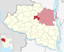
Adamdighi Upazila (Bengali: আদমদিঘী উপজেলা) is an upazila of Bogra District in the Division of Rajshahi, Bangladesh. Adamdighi Thana was established in 1821 and was converted into an upazila in 1983.[4] It is named after its administrative center, the town of Adamdighi. Local legend has it that its name came from a Muslim saint, Baba Adam, who visited and dug a dighi (tank) for water storage.[5]
Geography
[edit]Adamdighi Upazila has a total area of 168.83 square kilometres (65.19 sq mi).[1] It is the westernmost upazila of Bogra District. It borders Joypurhat District to the north, Dhupchanchia Upazila to the north and east, Kahaloo and Nandigram upazilas to the east, and Naogaon District to the south and west.[4]
Demographics
[edit]| Year | Pop. (000) | ±% |
|---|---|---|
| 1981 | 137 | — |
| 1991 | 170 | +24.1% |
| 2001 | 187 | +10.0% |
| 2011 | 195 | +4.3% |
| 2022 | 207 | +6.2% |
| Source: Bangladesh Bureau of Statistics[1] | ||
According to the 2011 Census of Bangladesh, Adamdighi Upazila had 49,600 households and a population of 195,186. 36,157 (18.52%) were under 10 years of age. Adamdighi had a literacy rate (age 7 and over) of 54.57%, compared to the national average of 51.8%, and a sex ratio of 1005 females per 1000 males. 39,946 (20.47%) lived in urban areas.[1][7]
Points of interest
[edit]Administration
[edit]
Adamdighi Upazila is divided into Santahar Municipality and six union parishads: Adamdighi Sadar, Chapapur, Chhatiangram, Kundugram, Nashratpur, and Santahar. The union parishads are subdivided into 100 mauzas and 179 villages.
Santahar Municipality is subdivided into 9 wards and 35 mahallas.[1]
Transport
[edit]Santahar railway station is a rail junction between the main line connecting Darshana and Chilahati and the branch line connecting Santahar and Kaunia. In July 2014 between 15 and 20 intercity and 7 mail trains a day departed from Santahar.
Rail station Chhatiangram is on the main line connecting Darshana and Chilahati. In July 2014 it was served by between 10 and 14 intercity and 4 mail trains a day.
Rail stations Adamdighi and Nashratpur are on the branch line connecting Santahar and Kaunia. In July 2014 they were served by six or eight intercity and six mail trains a day.[8]
Education
[edit]There are seven colleges in the upazila. Santahar Government College is the only public one. Private colleges include Adamdighi Rahim Uddin Degree College, Nasratpur Degree College, and Shahid Ahsanul Haque Degree College.[1]
The madrasa education system includes one fazil madrasa.[9]
Notable residents
[edit]- Kasim Uddin Ahmed, Member of Parliament, served as the upazila Awami League president for 44 years.[10]
- Rani Bhabani, zamindar, was born at Chhatiangram in 1716.[11]
- Khan Muhammad Saifullah Al Mehdi (born 1988), member of Parliament
See also
[edit]References
[edit]- ^ a b c d e f "Bangladesh Population and Housing Census 2011 Zila Report – Bogra" (PDF). bbs.gov.bd. Bangladesh Bureau of Statistics.
- ^ National Report (PDF). Population and Housing Census 2022. Vol. 1. Dhaka: Bangladesh Bureau of Statistics. November 2023. p. 401. ISBN 978-9844752016.
- ^ "Bangladesh Postal Code". Dhaka: Bangladesh Postal Department under the Department of Posts and Telecommunications of the Ministry of Posts, Telecommunications and Information Technology of the People's Republic of Bangladesh. 21 October 2024.
- ^ a b c d Md Rezaul Karim (2012), "Adamdighi Upazila", in Sirajul Islam and Ahmed A. Jamal (ed.), Banglapedia: National Encyclopedia of Bangladesh (Second ed.), Asiatic Society of Bangladesh
- ^ Bari, Latiful (1979). Bangladesh District Gazetteers: Bogra. Dacca: Bangladesh Government Press. p. 315. OCLC 708216.
- ^ Population and Housing Census 2022 - District Report: Bogura (PDF). District Series. Dhaka: Bangladesh Bureau of Statistics. June 2024. ISBN 978-984-475-235-1.
- ^ "Community Tables: Bogra district" (PDF). bbs.gov.bd. Bangladesh Bureau of Statistics. 2011.
- ^ "Santahar Schedule". Bangladesh Railways. Retrieved August 8, 2014.
- ^ "List of Institutions". Ministry of Education. Retrieved July 15, 2014.
- ^ "Bangabandhu's relatives, Hasina's 'Noya Chacha' on Razakar list: Protests countrywide". The Business Standard. 17 December 2019.
- ^ Mahmood, ABM (2012). "Rani Bhabani". In Sirajul Islam and Ahmed A. Jamal (ed.). Banglapedia: National Encyclopedia of Bangladesh (Second ed.). Asiatic Society of Bangladesh.

