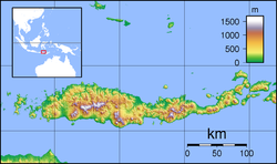
1992 Flores earthquake and tsunami
| UTC time | 1992-12-12 05:29:26 |
|---|---|
| ISC event | 257091 |
| USGS-ANSS | ComCat |
| Local date | 12 December 1992 |
| Local time | 13:29 WITA (Indonesia Central Standard Time) |
| Magnitude | 7.8 Mw |
| Depth | 27.7 km (17.2 mi) |
| Epicenter | 8°28′48″S 121°53′46″E / 8.480°S 121.896°E[1] |
| Areas affected | Flores Indonesia |
| Max. intensity | MMI VIII (Severe)[2] |
| Tsunami | Yes |
| Casualties | 2,500 dead 500 injured.[1] |
The 1992 Flores earthquake and tsunami occurred on 12 December on the island of Flores in Indonesia. With a magnitude of 7.8 and a maximum Mercalli intensity of VIII (Severe), it was the largest and also the deadliest earthquake in 1992 and in the Lesser Sunda Islands region. The earthquake was caused by slip on the Flores Thrust fault. This fault dips to the south underneath Flores Island. The epicenters of most earthquakes on the Flores Thrust are on Flores Island.
Earthquake
[edit]The earthquake was the result of shallow thrust faulting along a fault located in the back-arc region between the Sunda and Banda island arcs. The Flores Thrust represents a back-arc thrust fault that accommodated tectonic deformation between the Australian and Sunda plates. This structure runs for over 1,500 km (930 mi). Its eastern segment was responsible for producing the earthquake.[3]
Description
[edit]The earthquake occurred at 13:29:26 WITA and was followed by several serious aftershocks.[4] At least 2,500 people were killed or went missing near Flores, including 1,490 at Maumere and 700 on Babi.[1] More than 500 people were injured and 90,000 were left homeless.[1] Nineteen people were killed and 130 houses were destroyed on Kalaotoa.[1] Damage was assessed at exceeding US$100 million.[4] Approximately 90% of the buildings were destroyed at Maumere, the hardest-hit town, by the earthquake and ensuing tsunami while 50% to 80% of the structures on Flores were damaged or destroyed.[1] Electricity in the general area and the port of Maumere was shut down.[4] Maumere's hospital was completely destroyed, and patients were treated in tents.[4] Damage also occurred on Sumba and Alor.[1]
Tsunami
[edit]Wave run-up heights of 3–4 m (9.8–13.1 ft) occurred along the eastern coast of Maumere. The maximum run-up height was measured at Riangkroko village at 26 m (85 ft); the tsunami killed 137 villagers. Located along the Nipah River, the tsunami traveled 600 m (2,000 ft) inland. It washed away the whole village and stripped away coconut trees, leaving only roots. In another village 6 km (3.7 mi) north, Bou-Tanabeten, the tsunami run-up was 12 m (39 ft). Along other tsunami-hit locations, most trees remained standing. At Wuhring, a village 5 km (3.1 mi) from Maumere, 3 m (9.8 ft) waves swept through the village and killed 100 people. On Babi Island, the tsunami left human remains hanging on trees; 263 deaths occurred on the island and two villages were badly damaged. The maximum run-up on the island was recorded at 7.3 m (24 ft). Wave reflection effect off Flores Island may have partly contributed to the tsunami's destructive effects on Babi Island.[5]
Relief efforts
[edit]The Indonesian government sent rescue and relief missions to earthquake-stricken areas and declared the earthquake a national disaster.[4] The Indonesian Air Force provided assistance, mostly transporting medicine and clothing.[4] Malaria and influenza rose significantly after the disaster.[4] Babi Island survivors were evacuated since all the houses on the island were demolished.[4] International relief efforts were hindered by the onset of the rainy season.[4]
The Indonesian government also requested assistance from the international community. Agencies such as the Asian Development Bank, along with the World Bank, the Australian Agency for International Development, the Japanese Overseas Cooperation Fund, and others, made a coordinated effort to support reconstruction. Each agency concentrated on sectors and locations in which it had experience.[6]
See also
[edit]References
[edit]- ^ a b c d e f g Significant Earthquakes of the World in 1992 Archived 2009-09-12 at the Wayback Machine United States Geological Survey
- ^ EXPO-CAT Earthquake Catalog, Version 2007-12, United States Geological Survey, December 1, 2008
- ^ Felix, Raquel P.; Hubbard, Judith A.; Bradley, Kyle E.; Lythgoe, Karen H.; Li, Linlin; Switzer, Adam D. (2022). "Tsunami hazard in Lombok and Bali, Indonesia, due to the Flores back-arc thrust". Nat. Hazards Earth Syst. Sci. 22 (5): 1665–1682. Bibcode:2022NHESS..22.1665F. doi:10.5194/nhess-22-1665-2022.
- ^ a b c d e f g h i Reports 1–9 United Nations Department of Humanitarian Affairs
- ^ Yeh, Harry; Imamura, Fumihiko; Synolakis, Costas; Tsuji, Yoshinobu; Liu, Philip; Shi, Shaozhong (1993). "The Flores Island tsunamis". Eos. 74 (33): 369–373. Bibcode:1993EOSTr..74..369Y. doi:10.1029/93EO00381.
- ^ Some details are provided in Asian Development Bank, Project Performance Audit Report on the Flores Emergency Reconstruction Project, October 2000.
External links
[edit]- The International Seismological Centre has a bibliography and/or authoritative data for this event.


