Avital (moshav)
Appearance
(Redirected from אֲבִיטַל)
Avital
אֲבִיטַל | |
|---|---|
 | |
| Etymology: Named after Abital | |
| Coordinates: 32°33′29″N 35°18′21″E / 32.55806°N 35.30583°E | |
| Country | Israel |
| District | Northern |
| Council | Gilboa |
| Affiliation | Moshavim Movement |
| Founded | 1953 |
| Founded by | Iranian, Turkish and Kurdish Jews |
| Population (2022)[1] | 515 |
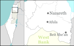
Avital (Hebrew: אֲבִיטַל) is a moshav in northern Israel. Located ten kilometers south of Afula, it falls under the jurisdiction of Gilboa Regional Council. In 2022 its population was 515.[1]
History
[edit]The village was founded in 1953 by immigrants from Iran and Turkey as part of the Moshavim Movement.
Avital is located on land that until 1933 belonged to the Palestinian village of Zir'in.[2]
The name is connected to King David, Avital was one of his wives (2 Samuel 3:4). But tal (eng. dew) reminds also of David's lament in this area: "O mountains of Gilboa, may You have no dew" (2 Samuel 1:21).[3]
See also
[edit]References
[edit]- ^ a b "Regional Statistics". Israel Central Bureau of Statistics. Retrieved 21 March 2024.
- ^ Khalidi, W. (1992). All That Remains: The Palestinian Villages Occupied and Depopulated by Israel in 1948. Washington D.C.: Institute for Palestine Studies. p. 340. ISBN 0-88728-224-5.
- ^ Bitan, Hanna: 1948-1998: Fifty Years of 'Hityashvut': Atlas of Names of Settlements in Israel, Jerusalem 1999, Carta, p. 1, ISBN 965-220-423-4

